
Goldsboro topographic map
Interactive map
Click on the map to display elevation.
About this map
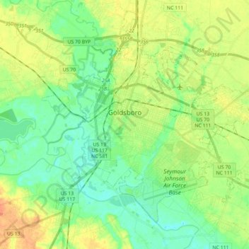
Name: Goldsboro topographic map, elevation, terrain.
Location: Goldsboro, Wayne County, North Carolina, United States (35.31243 -78.06589 35.44312 -77.89099)
Average elevation: 33 m
Minimum elevation: 13 m
Maximum elevation: 66 m
Other topographic maps
Click on a map to view its topography, its elevation and its terrain.
Ridgewood
United States > North Carolina > Wayne County > Goldsboro
Ridgewood, Goldsboro, Wayne County, North Carolina, 27534, United States
Average elevation: 36 m
Elroy
United States > North Carolina > Wayne County
Elroy, Wayne County, North Carolina, United States
Average elevation: 30 m