
Lügde topographic map
Interactive map
Click on the map to display elevation.
About this map
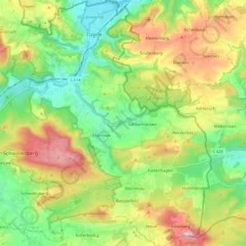
Name: Lügde topographic map, elevation, terrain.
Location: Lügde, Kreis Lippe, North Rhine-Westphalia, 32676, Germany (51.84963 9.18605 51.97769 9.34621)
Average elevation: 242 m
Minimum elevation: 91 m
Maximum elevation: 498 m
Other topographic maps
Click on a map to view its topography, its elevation and its terrain.
Lemgo
Germany > North Rhine-Westphalia > Kreis Lippe
Lemgo, Kreis Lippe, North Rhine-Westphalia, 32657, Germany
Average elevation: 173 m
Lügde
Germany > North Rhine-Westphalia > Kreis Lippe
Lügde, Kreis Lippe, North Rhine-Westphalia, Germany
Average elevation: 196 m
Oerlinghausen
Germany > North Rhine-Westphalia > Kreis Lippe > Oerlinghausen
Oerlinghausen, Kreis Lippe, North Rhine-Westphalia, 33813, Germany
Average elevation: 196 m
Detmold
Germany > North Rhine-Westphalia > Kreis Lippe
Detmold, Kreis Lippe, North Rhine-Westphalia, Germany
Average elevation: 202 m