
Lumphini Park topographic map
Interactive map
Click on the map to display elevation.
About this map
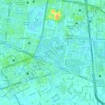
Name: Lumphini Park topographic map, elevation, terrain.
Location: Lumphini Park, Pathum Wan District, Bangkok, 10330, Thailand (13.72673 100.53764 13.73423 100.54565)
Average elevation: 9 m
Minimum elevation: 0 m
Maximum elevation: 39 m
Other topographic maps
Click on a map to view its topography, its elevation and its terrain.
Benchakitti Park
Benchakitti Park, Khlong Toei District, Bangkok, Thailand
Average elevation: 9 m
Sanam Luang
Sanam Luang, Phra Nakhon District, Bangkok, 10200, Thailand
Average elevation: 7 m
Bang Sue District
Bang Sue District, Bangkok, 10800, Thailand
Average elevation: 5 m
Vadhana District
Vadhana District, Bangkok, 10110, Thailand
Average elevation: 7 m
Khlong Toei District
Khlong Toei District, Bangkok, Thailand
Average elevation: 7 m
Bang Khun Thian District
Bang Khun Thian District, Bangkok, 10150, Thailand
Average elevation: 2 m
Bird Island
Bird Island, Bangkok, Dusit District, Bangkok, 10300, Thailand
Average elevation: 7 m
Dao Khanong River
Dao Khanong River, Bangkok, Rat Burana District, Bangkok, 10140, Thailand
Average elevation: 6 m