
The Anvil topographic map
Interactive map
Click on the map to display elevation.
About this map
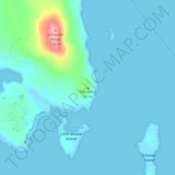
Name: The Anvil topographic map, elevation, terrain.
Location: The Anvil, Hancock County, Maine, 04613, USA (44.34170 -68.04589 44.34180 -68.04579)
Average elevation: 14 m
Minimum elevation: -2 m
Maximum elevation: 128 m
Other topographic maps
Click on a map to view its topography, its elevation and its terrain.
Dog Island
Dog Island, Eastport, Washington County, Maine, 04631, USA
Average elevation: 26 m
Tim Mountain
USA > Maine > Tim Pond Township
Tim Mountain, Tim Pond Township, Franklin County, Maine, USA
Average elevation: 793 m
Tim Pond
USA > Maine > Tim Pond Township
Tim Pond, Green Gate Road, Tim Pond Township, Franklin County, Maine, USA
Average elevation: 635 m
Spencer Bay
Spencer Bay, Fire Rd 7C, Piscataquis County, Maine, USA
Average elevation: 341 m
Phippsburg
USA > Maine > Phippsburg
Phippsburg, Sagadahoc County, Maine, 04562, USA
Average elevation: 23 m
Cunningham Mountains
Cunningham Mountains, Penobscot County, Maine, USA
Average elevation: 262 m
Kidney Pond
Kidney Pond, Colt's Point Trail, Piscataquis County, Maine, USA
Average elevation: 339 m