
Uyuni topographic map
Interactive map
Click on the map to display elevation.
About this map
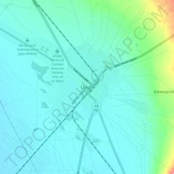
Name: Uyuni topographic map, elevation, terrain.
Location: Uyuni, Provincia Antonio Quijarro, Potosí, 691, Bolivia (-20.50284 -66.86391 -20.42284 -66.78391)
Average elevation: 3,675 m
Minimum elevation: 3,658 m
Maximum elevation: 3,770 m
Founded in 1890 as a trading post, the city has a population of 29,672 (2012 official census). The town has an extensive street-market. It lies at the edge of an extensive plain at an elevation of 3,700 m (12,139 ft) above sea level, with more mountainous country to the east.