
Breithorn Centrale topographic map
Interactive map
Click on the map to display elevation.
About this map
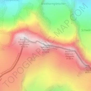
Name: Breithorn Centrale topographic map, elevation, terrain.
Location: Breithorn Centrale, Ayas, Valle d'Aosta, Italia (45.93861 7.75665 45.93871 7.75675)
Average elevation: 3,588 m
Minimum elevation: 2,907 m
Maximum elevation: 4,142 m
Other topographic maps
Click on a map to view its topography, its elevation and its terrain.
Champoluc
Italia > Valle d'Aosta > Ayas > Champoluc
Champoluc, Ayas, Valle d'Aosta, 11020, Italia
Average elevation: 1,968 m
Antagnod
Italia > Valle d'Aosta > Ayas
Antagnod, Ayas, Valle d'Aosta, 11020, Italia
Average elevation: 1,930 m