
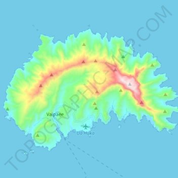
Ua Huka topographic map
Interactive map
Click on the map to display elevation.
About this map
Name: Ua Huka topographic map, elevation, terrain.
Average elevation: 101 m
Minimum elevation: -1 m
Maximum elevation: 855 m
Other topographic maps
Click on a map to view its topography, its elevation and its terrain.
Kaie
France, Polynésie française (eaux territoriales) > French Polynesia > Ua Huka
Kaie, Ua Huka, Marquesas Islands, French Polynesia, France, Polynésie française (eaux territoriales)
Average elevation: 55 m