
Great Doward topographic map
Interactive map
Click on the map to display elevation.
About this map
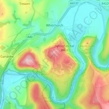
Name: Great Doward topographic map, elevation, terrain.
Average elevation: 85 m
Minimum elevation: 12 m
Maximum elevation: 220 m
The Great Doward area is marked by "extensive stratified limestone mountains" and the Great Doward Hill is said to contain "large deposits of rich iron-ore of a peculiar quality".[5][6] A lane in the area is called Black Stone Kiln's Lane, indicating historical economic activity here.[7] To the west, the area is woody with wild elevations, interspersed with tame swells and hollows.[4] Maliscot Wood lies to the southeast of The Doward.[7] The woodland is part of an Area of Outstanding Natural Beauty (AONB), and is protected by the Herefordshire Nature Trust.