
Enceinte protohistorique de la Rode topographic map
Interactive map
Click on the map to display elevation.
About this map
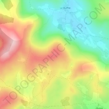
Name: Enceinte protohistorique de la Rode topographic map, elevation, terrain.
Average elevation: 1,029 m
Minimum elevation: 930 m
Maximum elevation: 1,138 m
Other topographic maps
Click on a map to view its topography, its elevation and its terrain.
Hures-la-Parade
France > Occitania > Hures-la-Parade
Hures-la-Parade, Florac, Lozère, Occitania, Metropolitan France, 48150, France
Average elevation: 915 m