
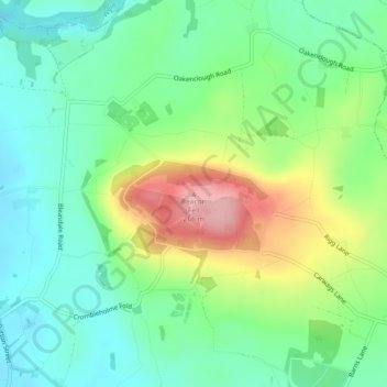
Beacon Fell topographic map
Interactive map
Click on the map to display elevation.
About this map
Name: Beacon Fell topographic map, elevation, terrain.
Average elevation: 167 m
Minimum elevation: 117 m
Maximum elevation: 263 m
Other topographic maps
Click on a map to view its topography, its elevation and its terrain.
Lower Bartle
United Kingdom > England > Lancashire > Preston > Woodplumpton
Lower Bartle, Woodplumpton, Preston, Lancashire, England, PR4 0RX, United Kingdom
Average elevation: 30 m
Ash
United Kingdom > England > Lancashire > Preston
Ash, Water Head, Lane Ends, Ashton-on-Ribble, Preston, Lancashire, England, PR2 3TU, United Kingdom
Average elevation: 28 m
Inglewhite
United Kingdom > England > Lancashire > Preston > Inglewhite
Inglewhite, Goosnargh, Preston, Lancashire, North West England, England, PR3 2LE, United Kingdom
Average elevation: 79 m
Whitechapel
United Kingdom > England > Lancashire > Preston > Whitechapel
Whitechapel, Goosnargh, Preston, Lancashire, North West England, England, PR3 2EX, United Kingdom
Average elevation: 123 m
Preston
United Kingdom > England > Lancashire > Preston
Preston, Lancashire, North West England, England, United Kingdom
Average elevation: 47 m
Goosnargh
United Kingdom > England > Lancashire > Preston
Goosnargh, Preston, Lancashire, North West England, England, United Kingdom
Average elevation: 107 m
Barton
United Kingdom > England > Lancashire > Preston
Barton, Preston, Lancashire, England, PR3 5AS, United Kingdom
Average elevation: 32 m
Whittingham
United Kingdom > England > Lancashire > Preston
Whittingham, Preston, Lancashire, England, United Kingdom
Average elevation: 78 m
Catforth
United Kingdom > England > Lancashire > Preston
Catforth, Preston, Lancashire, England, PR4 0HH, United Kingdom
Average elevation: 19 m