
Blanca Peak topographic map
Interactive map
Click on the map to display elevation.
About this map
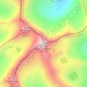
Name: Blanca Peak topographic map, elevation, terrain.
Location: Blanca Peak, Alamosa County, Colorado, United States (37.57756 -105.48558 37.57766 -105.48548)
Average elevation: 3,871 m
Minimum elevation: 3,347 m
Maximum elevation: 4,363 m
Blanca Peak is notable not only for its absolute height, but also for its great local relief and dominant position at the end of the range, rising high above the San Luis Valley to the west. For example, it rises nearly 7,000 feet (2,100 m) over the edge of the San Luis Valley in only 6 miles (9.7 km). Blanca is also the third most topographically prominent peak in Colorado; it is separated from the higher peaks in the Sawatch Range by relatively low Poncha Pass at 9,019 feet (2,749 m).
Other topographic maps
Click on a map to view its topography, its elevation and its terrain.
Lake Como
United States > Colorado > Alamosa County
Lake Como, Alamosa County, Colorado, United States
Average elevation: 3,718 m