
LaGrange topographic map
Interactive map
Click on the map to display elevation.
About this map
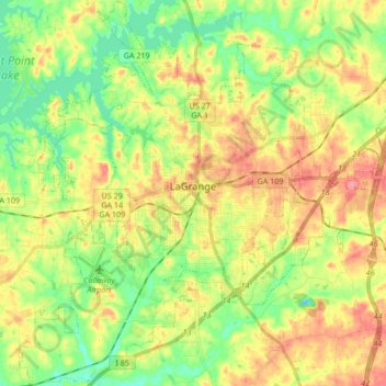
Name: LaGrange topographic map, elevation, terrain.
Location: LaGrange, Troup County, Georgia, United States (32.96588 -85.10746 33.10750 -84.94995)
Average elevation: 220 m
Minimum elevation: 181 m
Maximum elevation: 266 m
LaGrange is named after the country estate near Paris of the wife of the Marquis de La Fayette. When La Fayette, a Revolutionary War hero, visited Georgia in 1825 on a national tour, he remarked on the similarity of local topography to his wife's property.