
Sheerness Docks topographic map
Interactive map
Click on the map to display elevation.
About this map
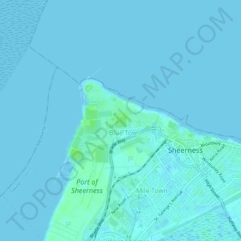
Name: Sheerness Docks topographic map, elevation, terrain.
Average elevation: 1 m
Minimum elevation: 0 m
Maximum elevation: 8 m
Other topographic maps
Click on a map to view its topography, its elevation and its terrain.
Upchurch
United Kingdom > England > Swale > Upchurch
Upchurch, Swale, Kent, South East England, England, ME9 7AE, United Kingdom
Average elevation: 12 m
Moor Street
United Kingdom > England > Swale > Moor Street
Moor Street, Swale, Kent, South East England, England, ME8 8QA, United Kingdom
Average elevation: 40 m
Milton Regis
United Kingdom > England > Swale > Sittingbourne
Milton Regis, Sittingbourne, Swale, Kent, South East England, England, ME10 2DU, United Kingdom
Average elevation: 16 m
Badlesmere
United Kingdom > England > Swale > Badlesmere
Badlesmere, Swale, Kent, South East, England, ME13 0NX, United Kingdom
Average elevation: 98 m
West Minster
United Kingdom > England > Swale
West Minster, Swale, Kent, South East, England, ME12 1LH, United Kingdom
Average elevation: 2 m
Capel Fleet Nature Reserve
United Kingdom > England > Swale
Capel Fleet Nature Reserve, Harty Ferry Road, Leysdown, Swale, Kent, South East, England, ME12 4BG, United Kingdom
Average elevation: 5 m