
Karitane topographic map
Interactive map
Click on the map to display elevation.
About this map
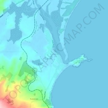
Name: Karitane topographic map, elevation, terrain.
Location: Karitane, Dunedin City, Otago, 9510, New Zealand (-45.65804 170.63430 -45.61804 170.67430)
Average elevation: 18 m
Minimum elevation: -1 m
Maximum elevation: 202 m
Other topographic maps
Click on a map to view its topography, its elevation and its terrain.
Dicks Hill
New Zealand > Otago > Dunedin City
Dicks Hill, Dunedin City, Otago, 9014, New Zealand
Average elevation: 128 m
Mount Charles
New Zealand > Otago > Dunedin City
Mount Charles, Dunedin City, Otago, New Zealand
Average elevation: 117 m
Dunedin
New Zealand > Otago > Dunedin City
Dunedin, Dunedin City, Otago, 9054, New Zealand
Average elevation: 110 m
Middlemarch
New Zealand > Otago > Dunedin City > Middlemarch
Middlemarch, Dunedin City, Otago, 9597, New Zealand
Average elevation: 210 m