
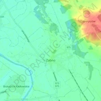
Żabno topographic map
Interactive map
Click on the map to display elevation.
About this map
Name: Żabno topographic map, elevation, terrain.
Average elevation: 186 m
Minimum elevation: 172 m
Maximum elevation: 224 m
Other topographic maps
Click on a map to view its topography, its elevation and its terrain.
Piotrkowice
Poland > Lesser Poland Voivodeship > Tarnów County
Piotrkowice, gmina Tuchów, Tarnów County, Lesser Poland Voivodeship, Poland
Average elevation: 286 m
Siedlec
Poland > Lesser Poland Voivodeship > Tarnów County
Siedlec, gmina Radłów, Tarnów County, Lesser Poland Voivodeship, Poland
Average elevation: 184 m
Dwudniaki
Poland > Lesser Poland Voivodeship > Tarnów County > Wierzchosławice
Dwudniaki, Wierzchosławice, gmina Wierzchosławice, Tarnów County, Lesser Poland Voivodeship, 33-122, Poland
Average elevation: 192 m
Skała
Poland > Lesser Poland Voivodeship > Tarnów County > Koszyce Małe
Skała, Koszyce Małe, gmina Tarnów, Tarnów County, Lesser Poland Voivodeship, 33-111, Poland
Average elevation: 231 m