
Willoughby topographic map
Interactive map
Click on the map to display elevation.
About this map
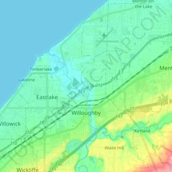
Name: Willoughby topographic map, elevation, terrain.
Location: Willoughby, Lake County, Ohio, 44094, United States (41.60412 -81.45269 41.70715 -81.36626)
Average elevation: 199 m
Minimum elevation: 172 m
Maximum elevation: 308 m
Other topographic maps
Click on a map to view its topography, its elevation and its terrain.
Mentor
United States > Ohio > Lake County
Mentor, Lake County, Ohio, 44060, United States
Average elevation: 198 m
Concord Mobile Home Park
United States > Ohio > Lake County > Willoughby
Concord Mobile Home Park, Willoughby, Lake County, Ohio, 44095, United States
Average elevation: 209 m
Eastlake
United States > Ohio > Lake County
Eastlake, Lake County, Ohio, 44095, United States
Average elevation: 187 m