Geolocate

Gear up for your next adventure:

As an Amazon Associate, this site earns from qualifying purchases at no extra cost to you.

👉 Easily get elevation data in JSON, GeoTIFF and KML formats using Elevation API
Thank you for supporting this site ❤️
Make a donation

Rocky topographic map

Click on the map to display elevation.

Gear up for your next adventure:

As an Amazon Associate, this site earns from qualifying purchases at no extra cost to you.

Gear up for your next adventure:

As an Amazon Associate, this site earns from qualifying purchases at no extra cost to you.

👉 Easily get elevation data in JSON, GeoTIFF and KML formats using Elevation API
Thank you for supporting this site ❤️
Make a donation

About this map

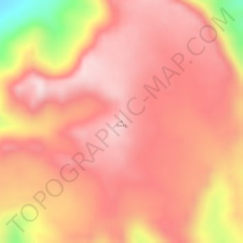
Name: Rocky topographic map, elevation, terrain.

Location: Rocky, Cook Shire, Queensland, Australia (-14.72783 144.77578 -14.72773 144.77588)

Average elevation: 417 m

Minimum elevation: 151 m

Maximum elevation: 509 m

Gear up for your next adventure:

As an Amazon Associate, this site earns from qualifying purchases at no extra cost to you.

👉 Easily get elevation data in JSON, GeoTIFF and KML formats using Elevation API
Thank you for supporting this site ❤️
Make a donation

Other topographic maps

Click on a map to view its topography, its elevation and its terrain.

Brighton

Australia > Queensland > City of Brisbane

Average elevation: 4 m

Stanthorpe

Australia > Queensland

Owing to its elevation, Stanthorpe features a subtropical highland climate (Cfb). At an altitude of 811 metres (2,661 ft), Stanthorpe holds the record for the lowest temperature recorded in Queensland at −10.6 °C (12.9 °F) on 23 June 1961.

Average elevation: 831 m

Mount Coot-tha

Australia > Queensland

It is often claimed that Mount Coot-tha is the "highest point in Brisbane", but, as the elevations above show, the peak known as Mount Coot-tha is not even the highest peak of the mountain as a whole with both Constitution Hill and The Summit being higher. However, Mount Coot-tha has a lookout with unobscured…

Average elevation: 88 m

Broadbeach

Australia > Queensland > Gold Coast City

Average elevation: 3 m

Gear up for your next adventure:

As an Amazon Associate, this site earns from qualifying purchases at no extra cost to you.

Thank you for supporting this site ❤️
Make a donation

Torbanlea

Australia > Queensland

Average elevation: 27 m

Rathdowney

Australia > Queensland

Average elevation: 216 m

Bunya

Australia > Queensland

Average elevation: 69 m

Maidenwell

Australia > Queensland

Average elevation: 492 m

Mount Sheridan

Australia > Queensland

Average elevation: 146 m

Gear up for your next adventure:

As an Amazon Associate, this site earns from qualifying purchases at no extra cost to you.

Thank you for supporting this site ❤️
Make a donation

Rasmussen

Australia > Queensland

Average elevation: 21 m

Doughboy

Australia > Queensland > Bundaberg Region

Average elevation: 245 m

Whiteside

Australia > Queensland

Average elevation: 47 m

Rockville

Australia > Queensland

Average elevation: 611 m

Gear up for your next adventure:

As an Amazon Associate, this site earns from qualifying purchases at no extra cost to you.

Thank you for supporting this site ❤️
Make a donation

Aurukun

Australia > Queensland

Average elevation: 33 m

Smithfield

Australia > Queensland

Average elevation: 95 m

Pioneer

Australia > Queensland

Average elevation: 364 m

Deeral

Australia > Queensland

Average elevation: 28 m

Gear up for your next adventure:

As an Amazon Associate, this site earns from qualifying purchases at no extra cost to you.

Thank you for supporting this site ❤️
Make a donation

North Deep Creek

Australia > Queensland

Average elevation: 119 m

Tarong

Australia > Queensland

Average elevation: 444 m

Longreach

Australia > Queensland

Average elevation: 225 m

River Ranch

Australia > Queensland

Average elevation: 27 m

D'aguilar

Australia > Queensland

Average elevation: 134 m

Gear up for your next adventure:

As an Amazon Associate, this site earns from qualifying purchases at no extra cost to you.

Thank you for supporting this site ❤️
Make a donation

Mons

Australia > Queensland > Sunshine Coast Regional

Average elevation: 72 m

Granite Creek

Australia > Queensland > Mareeba

Average elevation: 400 m

Gordonvale

Australia > Queensland

Average elevation: 98 m

Mingela

Australia > Queensland

Average elevation: 258 m

Cannonvale

Australia > Queensland

Average elevation: 90 m

Gear up for your next adventure:

As an Amazon Associate, this site earns from qualifying purchases at no extra cost to you.

Thank you for supporting this site ❤️
Make a donation

Mungy

Australia > Queensland

Average elevation: 292 m

Woodstock

Australia > Queensland

Average elevation: 150 m

Innes Park

Australia > Queensland > Bundaberg Region

Average elevation: 15 m

Lake Tinaroo

Australia > Queensland

Average elevation: 710 m

Alexandra Hills

Australia > Queensland

Scribbly Gums Conservation Area is located on the eastern edge of Alexandra Hills, bordered by Redland Hospital to the east, and Flinders St and Winchester Rd to the north. The conservation area occupies approximately 152 hectares and contains the Redlands Track Park - a collection of 30+ mountain bike trails…

Average elevation: 34 m

Gear up for your next adventure:

As an Amazon Associate, this site earns from qualifying purchases at no extra cost to you.

Thank you for supporting this site ❤️
Make a donation

Kabra

Australia > Queensland

Average elevation: 76 m

Daintree National Park

Australia > Queensland

Average elevation: 425 m

Darra

Australia > Queensland

Average elevation: 33 m

Lahore Park

Australia > Queensland

Average elevation: 6 m

Gear up for your next adventure:

As an Amazon Associate, this site earns from qualifying purchases at no extra cost to you.

Thank you for supporting this site ❤️
Make a donation

Kelvin Grove

Australia > Queensland

Average elevation: 27 m

Rangeville

Australia > Queensland

Average elevation: 596 m

Lady Musgrave Island

Australia > Queensland

Average elevation: 0 m

Shailer Park

Australia > Queensland

Average elevation: 46 m

Gear up for your next adventure:

As an Amazon Associate, this site earns from qualifying purchases at no extra cost to you.

Thank you for supporting this site ❤️
Make a donation

Moa Island

Australia > Queensland

Average elevation: 18 m

Ashwell

Australia > Queensland

Average elevation: 108 m

Passchendaele

Australia > Queensland

Average elevation: 807 m

Everton Hills

Australia > Queensland

Average elevation: 64 m

Gear up for your next adventure:

As an Amazon Associate, this site earns from qualifying purchases at no extra cost to you.

Thank you for supporting this site ❤️
Make a donation

Nepean Island

Australia > Queensland

Average elevation: 0 m

Southbrook

Australia > Queensland

Average elevation: 526 m

Silverwood

Australia > Queensland

Average elevation: 624 m

Tanah Merah

Australia > Queensland

Average elevation: 19 m

Gear up for your next adventure:

As an Amazon Associate, this site earns from qualifying purchases at no extra cost to you.

Thank you for supporting this site ❤️
Make a donation

Blunder Creek

Australia > Queensland

Average elevation: 13 m

Glenroy

Australia > Queensland

Average elevation: 134 m

Greenlands

Australia > Queensland

Average elevation: 827 m

Bargara

Australia > Queensland > Bundaberg Region

Average elevation: 8 m

Middlebrook

Australia > Queensland

Average elevation: 743 m

Gear up for your next adventure:

As an Amazon Associate, this site earns from qualifying purchases at no extra cost to you.

Thank you for supporting this site ❤️
Make a donation

Sarina

Australia > Queensland

Average elevation: 129 m

Georgetown

Australia > Queensland

Average elevation: 356 m

Holland Park

Australia > Queensland

Average elevation: 54 m

Kin Kin

Australia > Queensland

Average elevation: 141 m

Gregors Creek

Australia > Queensland

Average elevation: 194 m

Gear up for your next adventure:

As an Amazon Associate, this site earns from qualifying purchases at no extra cost to you.

Thank you for supporting this site ❤️
Make a donation

Blunder Creek

Australia > Queensland

Average elevation: 15 m

Heathwood

Australia > Queensland

Average elevation: 38 m

Snapper Island

Australia > Queensland

Average elevation: 2 m

Wyberba

Australia > Queensland

Average elevation: 835 m

Captain Burke Park

Australia > Queensland

Average elevation: 18 m

Gear up for your next adventure:

As an Amazon Associate, this site earns from qualifying purchases at no extra cost to you.

Thank you for supporting this site ❤️
Make a donation

Joyner

Australia > Queensland

Average elevation: 31 m

Mer Island

Australia > Queensland

Average elevation: 30 m

Top Camp

Australia > Queensland > Toowoomba

Top Camp is 9 kilometres (6 mi) from the Toowoomba city centre via the New England Highway. It is immediately to the west of the Great Dividing Range and is at an elevation of 580 to 630 metres (1,900 to 2,070 ft).The highway passes through the eastern part of the locality from north (Kearney Springs) to south…

Average elevation: 604 m

Dalrymple Heights

Australia > Queensland

Average elevation: 687 m

Gear up for your next adventure:

As an Amazon Associate, this site earns from qualifying purchases at no extra cost to you.

Thank you for supporting this site ❤️
Make a donation

Labrador

Australia > Queensland > Gold Coast City

Average elevation: 6 m

Windorah

Australia > Queensland

Average elevation: 158 m

Miami

Australia > Queensland > Gold Coast City

Average elevation: 4 m

Kooralbyn

Australia > Queensland

Average elevation: 211 m

Balgowan

Australia > Queensland

Average elevation: 445 m

Gear up for your next adventure:

As an Amazon Associate, this site earns from qualifying purchases at no extra cost to you.

Thank you for supporting this site ❤️
Make a donation

Upper Coomera

Australia > Queensland > Gold Coast City

Average elevation: 43 m

Eungella Dam

Australia > Queensland

Average elevation: 542 m

Logan Village

Australia > Queensland

Average elevation: 52 m

Crystal Brook

Australia > Queensland

Average elevation: 48 m

Redbank Plains

Australia > Queensland

Average elevation: 68 m

Gear up for your next adventure:

As an Amazon Associate, this site earns from qualifying purchases at no extra cost to you.

Thank you for supporting this site ❤️
Make a donation

Blackall

Australia > Queensland

Average elevation: 342 m

Upper Flagstone

Australia > Queensland

Average elevation: 470 m

Cedar Creek

Australia > Queensland > Gold Coast City

Average elevation: 116 m

Austinville

Australia > Queensland > Gold Coast City

Average elevation: 241 m

Gear up for your next adventure:

As an Amazon Associate, this site earns from qualifying purchases at no extra cost to you.

Thank you for supporting this site ❤️
Make a donation

Doonan

Australia > Queensland > Sunshine Coast Regional

Average elevation: 48 m

Moogerah

Australia > Queensland

Average elevation: 356 m

Victoria Point

Australia > Queensland

Average elevation: 8 m

Dauan Island

Australia > Queensland

Average elevation: 27 m

Gear up for your next adventure:

As an Amazon Associate, this site earns from qualifying purchases at no extra cost to you.

Thank you for supporting this site ❤️
Make a donation

Magnetic Island

Australia > Queensland > Townsville

Average elevation: 54 m

Doomadgee

Australia > Queensland

Average elevation: 52 m

Swan Lake

Australia > Queensland > Gold Coast City

Average elevation: 6 m

Gear up for your next adventure:

As an Amazon Associate, this site earns from qualifying purchases at no extra cost to you.

Thank you for supporting this site ❤️
Make a donation