
Make a donation
Gear up for your next adventure:
As an Amazon Associate, this site earns from qualifying purchases at no extra cost to you.
Corinthia Regional Unit topographic map
Click on the map to display elevation.
Make a donation
Gear up for your next adventure:
As an Amazon Associate, this site earns from qualifying purchases at no extra cost to you.
About this map
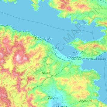
Name: Corinthia Regional Unit topographic map, elevation, terrain.
Average elevation: 403 m
Minimum elevation: -2 m
Maximum elevation: 2,364 m
Make a donation
Gear up for your next adventure:
As an Amazon Associate, this site earns from qualifying purchases at no extra cost to you.
Other topographic maps
Click on a map to view its topography, its elevation and its terrain.
Argos
Greece > Peloponnese, Western Greece and the Ionian > Argolis Regional Unit
Average elevation: 322 m
Megalopoli
Greece > Peloponnese, Western Greece and the Ionian > Arcadia Regional Unit > Municipal Unit of Megalopoli
Megalopoli is situated in a wide valley, surrounded by mountains: the Taygetus to the south, the Mainalo to the north, the Tsemperou to the southeast and the Lykaion to the west. Its elevation is 430 m above sea level. The river Alfeios flows through this valley, coming from the east and flowing to the north,…
Average elevation: 434 m
Koromilia - Vaskinas
Greece > Peloponnese, Western Greece and the Ionian > Arcadia Regional Unit > Municipal Unit of Leonidio
Average elevation: 797 m
Xylokastro
Greece > Peloponnese, Western Greece and the Ionian > Corinthia Regional Unit > Municipal Unit of Xylokastro
Average elevation: 52 m
Make a donation
Gear up for your next adventure:
As an Amazon Associate, this site earns from qualifying purchases at no extra cost to you.
Chrysovitsi
Greece > Peloponnese, Western Greece and the Ionian > Arcadia Regional Unit > Municipa Unit of Falanthos
Average elevation: 1,112 m
Kryoneri
Greece > Peloponnese, Western Greece and the Ionian > Corinthia Regional Unit > Municipal Unit of Sikyona
Average elevation: 718 m
Κάμπος Κοιλάδος
Greece > Peloponnese, Western Greece and the Ionian > Argolis Regional Unit > Municipal Unit of Kranidi
Average elevation: 31 m
Αλεξανδρή
Greece > Peloponnese, Western Greece and the Ionian > Achaia Regional Unit > Municipal Unit of Erineos > Panagopoula
Average elevation: 164 m
Make a donation
Gear up for your next adventure:
As an Amazon Associate, this site earns from qualifying purchases at no extra cost to you.
Archaia Pisa
Greece > Peloponnese, Western Greece and the Ionian > Elis Regional Unit > Municipal Unit of Archea Olympia
Average elevation: 82 m
Kalamaki Beach
Greece > Peloponnese, Western Greece and the Ionian > Zakynthos Regional Unit > Laganas Municipal Unit
Average elevation: 32 m
Rivio
Greece > Peloponnese, Western Greece and the Ionian > Aetolia-Acarnania Regional Unit > Municipal Unit of Fyteies
Average elevation: 102 m
Παραλία Πλάτανου
Greece > Peloponnese, Western Greece and the Ionian > Achaia Regional Unit > Municipal Unit of Akrata
Average elevation: 154 m
Make a donation
Gear up for your next adventure:
As an Amazon Associate, this site earns from qualifying purchases at no extra cost to you.
Akritochori
Greece > Peloponnese, Western Greece and the Ionian > Messenia Regional Unit > Koroni Municipal Unit
Average elevation: 176 m
Argostoli
Greece > Peloponnese, Western Greece and the Ionian > Kefallonia Regional Unit
Average elevation: 79 m
Plitra
Greece > Peloponnese, Western Greece and the Ionian > Laconia Regional Unit
Average elevation: 52 m
Kynopiastes
Greece > Peloponnese, Western Greece and the Ionian > Corfu Regional Unit
Average elevation: 117 m
Make a donation
Gear up for your next adventure:
As an Amazon Associate, this site earns from qualifying purchases at no extra cost to you.
Athani
Greece > Peloponnese, Western Greece and the Ionian > Lefkada Regional Unit > Municipal Unit of Apollonioi
Average elevation: 325 m
Stratos
Greece > Peloponnese, Western Greece and the Ionian > Aetolia-Acarnania Regional Unit > Municipal Unit of Stratos
Average elevation: 54 m
Palaiokastritsa
Greece > Peloponnese, Western Greece and the Ionian > Corfu Regional Unit
Average elevation: 154 m
Neromylos
Greece > Peloponnese, Western Greece and the Ionian > Zakynthos Regional Unit > Arkadii Municipal Unit
Average elevation: 38 m
Make a donation
Gear up for your next adventure:
As an Amazon Associate, this site earns from qualifying purchases at no extra cost to you.
Ano Karnezaika
Greece > Peloponnese, Western Greece and the Ionian > Argolis Regional Unit > Municipal Unit of Asini
Average elevation: 235 m
Exogi
Greece > Peloponnese, Western Greece and the Ionian > Ithaca Regional Unit
Average elevation: 102 m
Kardamyli
Greece > Peloponnese, Western Greece and the Ionian > Messenia Regional Unit > Municipal Unit of Lefktro
Average elevation: 96 m
Mykines
Greece > Peloponnese, Western Greece and the Ionian > Argolis Regional Unit > Municipal Unit of Mykines
Average elevation: 165 m
Make a donation
Gear up for your next adventure:
As an Amazon Associate, this site earns from qualifying purchases at no extra cost to you.
Fiskardo
Greece > Peloponnese, Western Greece and the Ionian > Kefallonia Regional Unit > Erisos Municipal Unit
Average elevation: 52 m
Κροκεές
Greece > Peloponnese, Western Greece and the Ionian > Laconia Regional Unit
Average elevation: 256 m
Glyfa
Greece > Peloponnese, Western Greece and the Ionian > Corfu Regional Unit > Barbati
Average elevation: 227 m
Eliki
Greece > Peloponnese, Western Greece and the Ionian > Achaia Regional Unit > Municipal Unit of Diakopto
Average elevation: 136 m
Make a donation
Gear up for your next adventure:
As an Amazon Associate, this site earns from qualifying purchases at no extra cost to you.
Matsoukata
Greece > Peloponnese, Western Greece and the Ionian > Kefallonia Regional Unit > Erisos Municipal Unit
Average elevation: 103 m
Sidari
Greece > Peloponnese, Western Greece and the Ionian > Corfu Regional Unit
Average elevation: 13 m
Highly salted sea
Greece > Peloponnese, Western Greece and the Ionian > Aetolia-Acarnania Regional Unit > Municipal Unit of Etoliko
Average elevation: 2 m
Doxa
Greece > Peloponnese, Western Greece and the Ionian > Arcadia Regional Unit > Municipal Unit of Tropaia
Average elevation: 552 m
Make a donation
Gear up for your next adventure:
As an Amazon Associate, this site earns from qualifying purchases at no extra cost to you.
Patras
Greece > Peloponnese, Western Greece and the Ionian > Achaia Regional Unit
A central feature of the urban geography of Patras is its division into upper and lower sections. This is the result of an interplay between natural geography and human settlement patterns; the lower section of the city (Kato Poli), which includes the 19th-century urban core and the port, is adjacent to the…
Average elevation: 283 m
Revmatia
Greece > Peloponnese, Western Greece and the Ionian > Messenia Regional Unit
Average elevation: 542 m
Glyfa
Greece > Peloponnese, Western Greece and the Ionian > Elis Regional Unit
Average elevation: 38 m
Corinth
Greece > Peloponnese, Western Greece and the Ionian > Corinthia Regional Unit
Average elevation: 21 m
Make a donation
Gear up for your next adventure:
As an Amazon Associate, this site earns from qualifying purchases at no extra cost to you.
Corinth
Greece > Peloponnese, Western Greece and the Ionian > Corinthia Regional Unit
Average elevation: 21 m
Ανδρούσα
Greece > Peloponnese, Western Greece and the Ionian > Messenia Regional Unit
Average elevation: 96 m
Asini
Greece > Peloponnese, Western Greece and the Ionian > Messenia Regional Unit > Koroni Municipal Unit > Koroni
Average elevation: 35 m
Argos
Greece > Peloponnese, Western Greece and the Ionian > Argolis Regional Unit
Average elevation: 322 m
Make a donation
Gear up for your next adventure:
As an Amazon Associate, this site earns from qualifying purchases at no extra cost to you.
Patras
Greece > Peloponnese, Western Greece and the Ionian > Achaia Regional Unit
A central feature of the urban geography of Patras is its division into upper and lower sections. This is the result of an interplay between natural geography and human settlement patterns; the lower section of the city (Kato Poli), which includes the 19th-century urban core and the port, is adjacent to the…
Average elevation: 283 m
Ancient Olympia
Greece > Peloponnese, Western Greece and the Ionian > Elis Regional Unit > Municipal Unit of Archea Olympia > Koskinas
Another location that has a special interest to both ancients and moderns is the stadium. It is basically a field with start and end lines marked off by transverse curbing. The athletes entered under an archway of a vaulted corridor at the start. Spectators sat mainly on the field's sloping flanks. The length…
Average elevation: 99 m
Kalavryta
Greece > Peloponnese, Western Greece and the Ionian > Achaia Regional Unit > Municipal Unit of Kalavryta
Average elevation: 984 m
Ancient Olympia
Greece > Peloponnese, Western Greece and the Ionian > Elis Regional Unit > Municipal Unit of Archea Olympia
Another location that has a special interest to both ancients and moderns is the stadium. It is basically a field with start and end lines marked off by transverse curbing. The athletes entered under an archway of a vaulted corridor at the start. Spectators sat mainly on the field's sloping flanks. The length…
Average elevation: 99 m
Make a donation
Gear up for your next adventure:
As an Amazon Associate, this site earns from qualifying purchases at no extra cost to you.
Margareika
Greece > Peloponnese, Western Greece and the Ionian > Zakynthos Regional Unit > Laganas Municipal Unit
Average elevation: 23 m
Kastella
Greece > Peloponnese, Western Greece and the Ionian > Laconia Regional Unit
Average elevation: 117 m
Mount Ainos National Park
Greece > Peloponnese, Western Greece and the Ionian > Kefallonia Regional Unit > Municipal Unit of Elios-Proni
Average elevation: 501 m
Plakoto
Greece > Peloponnese, Western Greece and the Ionian > Corfu Regional Unit > Glyfada
Average elevation: 68 m
Make a donation
Gear up for your next adventure:
As an Amazon Associate, this site earns from qualifying purchases at no extra cost to you.
Piso Sykia
Greece > Peloponnese, Western Greece and the Ionian > Achaia Regional Unit > Municipal Unit of Dymi > Κάτω Αχαΐα
Average elevation: 19 m
Roda
Greece > Peloponnese, Western Greece and the Ionian > Corfu Regional Unit
Average elevation: 25 m
Methoni
Greece > Peloponnese, Western Greece and the Ionian > Messenia Regional Unit > Methoni Municipal Unit
Average elevation: 36 m
Ermioni
Greece > Peloponnese, Western Greece and the Ionian > Argolis Regional Unit > Municipal Unit of Ermioni
Average elevation: 55 m
Make a donation
Gear up for your next adventure:
As an Amazon Associate, this site earns from qualifying purchases at no extra cost to you.
Eliki
Greece > Peloponnese, Western Greece and the Ionian > Achaia Regional Unit > Municipal Unit of Diakopto
Average elevation: 136 m
Nymphes
Greece > Peloponnese, Western Greece and the Ionian > Corfu Regional Unit
Average elevation: 152 m
Lefkimmi
Greece > Peloponnese, Western Greece and the Ionian > Corfu Regional Unit > Municipal Unit of Lefkimmi
Average elevation: 17 m
Ορχομενός
Greece > Peloponnese, Western Greece and the Ionian > Arcadia Regional Unit > Municipal Unit of Levidi
The most important monument is the theatre (4th–3rd BC) with a capacity of 4,000. At an altitude of 800 metres it offered a spectacular view during cultural events.
Average elevation: 740 m
Make a donation
Gear up for your next adventure:
As an Amazon Associate, this site earns from qualifying purchases at no extra cost to you.
Ξηροκάμπι
Greece > Peloponnese, Western Greece and the Ionian > Arcadia Regional Unit
Average elevation: 923 m
Corfu
Greece > Peloponnese, Western Greece and the Ionian > Corfu Regional Unit
Average elevation: 66 m
Methoni
Greece > Peloponnese, Western Greece and the Ionian > Messenia Regional Unit > Methoni Municipal Unit
Average elevation: 36 m
Rodia
Greece > Peloponnese, Western Greece and the Ionian > Messenia Regional Unit > Tripyla Municipal Unit
Average elevation: 607 m
Make a donation
Gear up for your next adventure:
As an Amazon Associate, this site earns from qualifying purchases at no extra cost to you.
Kokkala
Greece > Peloponnese, Western Greece and the Ionian > Elis Regional Unit > Βαρθολομιό
Average elevation: 12 m
Kassiopi
Greece > Peloponnese, Western Greece and the Ionian > Corfu Regional Unit > Kassopaia Municipal Unit
Average elevation: 59 m
Valtesiniko
Greece > Peloponnese, Western Greece and the Ionian > Arcadia Regional Unit > Municipal Unit of Kleitor
Average elevation: 1,115 m
Atheras
Greece > Peloponnese, Western Greece and the Ionian > Kefallonia Regional Unit > Paliki Municipal Unit
Average elevation: 96 m
Make a donation
Gear up for your next adventure:
As an Amazon Associate, this site earns from qualifying purchases at no extra cost to you.
Portocheli
Greece > Peloponnese, Western Greece and the Ionian > Argolis Regional Unit > Municipal Unit of Kranidi
Average elevation: 19 m
Moraitika
Greece > Peloponnese, Western Greece and the Ionian > Corfu Regional Unit > Municipal Unit of Meliteieis
Average elevation: 24 m
Mesolongi
Greece > Peloponnese, Western Greece and the Ionian > Aetolia-Acarnania Regional Unit
Average elevation: 108 m
Aigio
Greece > Peloponnese, Western Greece and the Ionian > Achaia Regional Unit
Average elevation: 371 m
Make a donation
Gear up for your next adventure:
As an Amazon Associate, this site earns from qualifying purchases at no extra cost to you.
Kyllini (Ziria)
Greece > Peloponnese, Western Greece and the Ionian > Corinthia Regional Unit > Municipal Unit of Xylokastro
Average elevation: 1,994 m
Σούλι
Greece > Peloponnese, Western Greece and the Ionian > Corinthia Regional Unit > Municipal Unit of Sikyona
Average elevation: 597 m
Sparta
Greece > Peloponnese, Western Greece and the Ionian > Laconia Regional Unit
Average elevation: 199 m
Κυπαρισσία
Greece > Peloponnese, Western Greece and the Ionian > Messenia Regional Unit > Kyparissia Municipal Unit
Average elevation: 152 m
Make a donation
Gear up for your next adventure:
As an Amazon Associate, this site earns from qualifying purchases at no extra cost to you.
Kontogialos
Greece > Peloponnese, Western Greece and the Ionian > Corfu Regional Unit > Pelekas
Average elevation: 65 m
Stemnitsa
Greece > Peloponnese, Western Greece and the Ionian > Arcadia Regional Unit > Municipal Unit of Trikolonoi
Stemnitsa (Greek: Στεμνίτσα) is a mountain village in the municipal unit of Trikolonoi, Arcadia, Peloponnese, Greece. It was the seat of the former municipality Trikolonoi. Stemnitsa is a traditional settlement and is considered one of the most beautiful villages in Arcadia, due to its picturesque…
Average elevation: 1,166 m
Ancient Olympia
Greece > Peloponnese, Western Greece and the Ionian > Elis Regional Unit > Municipal Unit of Archea Olympia > Koskinas
Another location that has a special interest to both ancients and moderns is the stadium. It is basically a field with start and end lines marked off by transverse curbing. The athletes entered under an archway of a vaulted corridor at the start. Spectators sat mainly on the field's sloping flanks. The length…
Average elevation: 99 m
Ρειχέα
Greece > Peloponnese, Western Greece and the Ionian > Laconia Regional Unit
Average elevation: 542 m
Make a donation
Gear up for your next adventure:
As an Amazon Associate, this site earns from qualifying purchases at no extra cost to you.
Levidi
Greece > Peloponnese, Western Greece and the Ionian > Arcadia Regional Unit > Municipal Unit of Levidi
Levidi (Greek: Λεβίδι) is a small town and a former municipality in Arcadia, Peloponnese, Greece. Since the 2011 local government reform it is part of the municipality Tripoli, of which it is a municipal unit. The municipal unit has an area of 312.641 km2. The town is situated on the northeastern slope…
Average elevation: 935 m
Elika
Greece > Peloponnese, Western Greece and the Ionian > Laconia Regional Unit
Average elevation: 197 m
Malthi
Greece > Peloponnese, Western Greece and the Ionian > Messenia Regional Unit
Average elevation: 390 m
Katomeri
Greece > Peloponnese, Western Greece and the Ionian > Lefkada Regional Unit
Average elevation: 24 m
Make a donation
Gear up for your next adventure:
As an Amazon Associate, this site earns from qualifying purchases at no extra cost to you.
Nafplio
Greece > Peloponnese, Western Greece and the Ionian > Argolis Regional Unit > Municipal Unit of Nafplio
Average elevation: 36 m
Corinth
Greece > Peloponnese, Western Greece and the Ionian > Corinthia Regional Unit
Average elevation: 185 m
Kato Lousi
Greece > Peloponnese, Western Greece and the Ionian > Achaia Regional Unit > Municipal Unit of Kalavryta
Average elevation: 1,172 m
Vytina
Greece > Peloponnese, Western Greece and the Ionian > Arcadia Regional Unit > Municipal Unit of Vytina
Due to its altitude and inland location, Vytina has a temperate climate with cold and snowy winters and warm summers with pleasant nights. Precipitation is abundant year round.
Average elevation: 1,036 m
Make a donation
Gear up for your next adventure:
As an Amazon Associate, this site earns from qualifying purchases at no extra cost to you.
Kastria
Greece > Peloponnese, Western Greece and the Ionian > Municipality of Kalavryta > Kastria
Average elevation: 976 m
Σωτήρα
Greece > Peloponnese, Western Greece and the Ionian > Municipality of Sparta > Σωτήρα
Average elevation: 728 m
Minia
Greece > Peloponnese, Western Greece and the Ionian > Kefallonia Regional Unit
Average elevation: 58 m
Ancient Olympia
Greece > Peloponnese, Western Greece and the Ionian > Elis Regional Unit > Municipal Unit of Archea Olympia
Another location that has a special interest to both ancients and moderns is the stadium. It is basically a field with start and end lines marked off by transverse curbing. The athletes entered under an archway of a vaulted corridor at the start. Spectators sat mainly on the field's sloping flanks. The length…
Average elevation: 99 m
Make a donation
Gear up for your next adventure:
As an Amazon Associate, this site earns from qualifying purchases at no extra cost to you.
Agios Nikolaos
Greece > Peloponnese, Western Greece and the Ionian > Elis Regional Unit > Zacharo > Agios Nikolaos
Average elevation: 4 m
Afionas
Greece > Peloponnese, Western Greece and the Ionian > Corfu Regional Unit
Average elevation: 26 m
Antipata
Greece > Peloponnese, Western Greece and the Ionian > Kefallonia Regional Unit > Pylaros Municipal Unit > Antipata
Average elevation: 387 m
Make a donation
Gear up for your next adventure:
As an Amazon Associate, this site earns from qualifying purchases at no extra cost to you.
Olympia
Greece > Peloponnese, Western Greece and the Ionian > Elis Regional Unit > Ancient Olympia
Average elevation: 57 m
Spartia
Greece > Peloponnese, Western Greece and the Ionian > Laconia Regional Unit
Average elevation: 833 m
Κροκεές
Greece > Peloponnese, Western Greece and the Ionian > Laconia Regional Unit > Κροκεές
Average elevation: 256 m
Κυπαρισσία
Greece > Peloponnese, Western Greece and the Ionian > Messenia Regional Unit > Kyparissia Municipal Unit
Average elevation: 152 m
Make a donation
Gear up for your next adventure:
As an Amazon Associate, this site earns from qualifying purchases at no extra cost to you.
Kilada
Greece > Peloponnese, Western Greece and the Ionian > Argolis Regional Unit > Municipal Unit of Kranidi
Average elevation: 17 m
Zacharo
Greece > Peloponnese, Western Greece and the Ionian > Elis Regional Unit > Zacharo Municipal Unit
Average elevation: 85 m
Myli
Greece > Peloponnese, Western Greece and the Ionian > Argolis Regional Unit > Municipal Unit of Lerna
Average elevation: 31 m
Gouvia
Greece > Peloponnese, Western Greece and the Ionian > Corfu Regional Unit
Average elevation: 29 m
Make a donation
Gear up for your next adventure:
As an Amazon Associate, this site earns from qualifying purchases at no extra cost to you.