
Corinthia Regional Unit topographic map
Interactive map
Click on the map to display elevation.
About this map
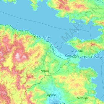
Name: Corinthia Regional Unit topographic map, elevation, terrain.
Average elevation: 403 m
Minimum elevation: -2 m
Maximum elevation: 2,364 m
Other topographic maps
Click on a map to view its topography, its elevation and its terrain.
Matsoukata
Greece > Peloponnese, Western Greece and the Ionian > Kefallonia Regional Unit > Erisos Municipal Unit
Average elevation: 103 m
Highly salted sea
Greece > Peloponnese, Western Greece and the Ionian > Aetolia-Acarnania Regional Unit > Municipal Unit of Etoliko
Average elevation: 2 m
Patras
Greece > Peloponnese, Western Greece and the Ionian > Achaia Regional Unit
A central feature of the urban geography of Patras is its division into upper and lower sections. This is the result of an interplay between natural geography and human settlement patterns; the lower section of the city (Kato Poli), which includes the 19th-century urban core and the port, is adjacent to the…
Average elevation: 283 m
Doxa
Greece > Peloponnese, Western Greece and the Ionian > Arcadia Regional Unit > Municipal Unit of Tropaia
Average elevation: 552 m
Sidari
Greece > Peloponnese, Western Greece and the Ionian > Corfu Regional Unit
Average elevation: 13 m
Revmatia
Greece > Peloponnese, Western Greece and the Ionian > Messenia Regional Unit
Average elevation: 542 m
Glyfa
Greece > Peloponnese, Western Greece and the Ionian > Elis Regional Unit
Average elevation: 38 m
Corinth
Greece > Peloponnese, Western Greece and the Ionian > Corinthia Regional Unit
Average elevation: 21 m
Corinth
Greece > Peloponnese, Western Greece and the Ionian > Corinthia Regional Unit
Average elevation: 21 m
Ανδρούσα
Greece > Peloponnese, Western Greece and the Ionian > Messenia Regional Unit
Average elevation: 96 m
Asini
Greece > Peloponnese, Western Greece and the Ionian > Messenia Regional Unit > Koroni Municipal Unit > Koroni
Average elevation: 35 m
Patras
Greece > Peloponnese, Western Greece and the Ionian > Achaia Regional Unit
A central feature of the urban geography of Patras is its division into upper and lower sections. This is the result of an interplay between natural geography and human settlement patterns; the lower section of the city (Kato Poli), which includes the 19th-century urban core and the port, is adjacent to the…
Average elevation: 283 m
Ancient Olympia
Greece > Peloponnese, Western Greece and the Ionian > Elis Regional Unit > Municipal Unit of Archea Olympia > Koskinas
Another location that has a special interest to both ancients and moderns is the stadium. It is basically a field with start and end lines marked off by transverse curbing. The athletes entered under an archway of a vaulted corridor at the start. Spectators sat mainly on the field's sloping flanks. The length…
Average elevation: 99 m
Ancient Olympia
Greece > Peloponnese, Western Greece and the Ionian > Elis Regional Unit > Municipal Unit of Archea Olympia
Another location that has a special interest to both ancients and moderns is the stadium. It is basically a field with start and end lines marked off by transverse curbing. The athletes entered under an archway of a vaulted corridor at the start. Spectators sat mainly on the field's sloping flanks. The length…
Average elevation: 99 m
Argos
Greece > Peloponnese, Western Greece and the Ionian > Argolis Regional Unit
Average elevation: 322 m
Margareika
Greece > Peloponnese, Western Greece and the Ionian > Zakynthos Regional Unit > Laganas Municipal Unit
Average elevation: 23 m
Kalavryta
Greece > Peloponnese, Western Greece and the Ionian > Achaia Regional Unit > Municipal Unit of Kalavryta
Average elevation: 984 m
Kastella
Greece > Peloponnese, Western Greece and the Ionian > Laconia Regional Unit
Average elevation: 117 m
Mount Ainos National Park
Greece > Peloponnese, Western Greece and the Ionian > Kefallonia Regional Unit > Municipal Unit of Elios-Proni
Average elevation: 501 m
Plakoto
Greece > Peloponnese, Western Greece and the Ionian > Corfu Regional Unit > Glyfada
Average elevation: 68 m
Piso Sykia
Greece > Peloponnese, Western Greece and the Ionian > Achaia Regional Unit > Municipal Unit of Dymi > Κάτω Αχαΐα
Average elevation: 19 m
Patras
Greece > Peloponnese, Western Greece and the Ionian > Achaia Regional Unit
A central feature of the urban geography of Patras is its division into upper and lower sections. This is the result of an interplay between natural geography and human settlement patterns; the lower section of the city (Kato Poli), which includes the 19th-century urban core and the port, is adjacent to the…
Average elevation: 283 m
Corinth
Greece > Peloponnese, Western Greece and the Ionian > Corinthia Regional Unit
Average elevation: 21 m
Methoni
Greece > Peloponnese, Western Greece and the Ionian > Messenia Regional Unit > Methoni Municipal Unit
Average elevation: 36 m
Roda
Greece > Peloponnese, Western Greece and the Ionian > Corfu Regional Unit
Average elevation: 25 m
Nymphes
Greece > Peloponnese, Western Greece and the Ionian > Corfu Regional Unit
Average elevation: 152 m
Eliki
Greece > Peloponnese, Western Greece and the Ionian > Achaia Regional Unit > Municipal Unit of Diakopto
Average elevation: 136 m
Lefkimmi
Greece > Peloponnese, Western Greece and the Ionian > Corfu Regional Unit > Municipal Unit of Lefkimmi
Average elevation: 17 m
Ορχομενός
Greece > Peloponnese, Western Greece and the Ionian > Arcadia Regional Unit > Municipal Unit of Levidi
The most important monument is the theatre (4th–3rd BC) with a capacity of 4,000. At an altitude of 800 metres it offered a spectacular view during cultural events.
Average elevation: 740 m
Methoni
Greece > Peloponnese, Western Greece and the Ionian > Messenia Regional Unit > Methoni Municipal Unit
Average elevation: 36 m
Ξηροκάμπι
Greece > Peloponnese, Western Greece and the Ionian > Arcadia Regional Unit
Average elevation: 923 m
Rodia
Greece > Peloponnese, Western Greece and the Ionian > Messenia Regional Unit > Tripyla Municipal Unit
Average elevation: 607 m
Kokkala
Greece > Peloponnese, Western Greece and the Ionian > Elis Regional Unit > Βαρθολομιό
Average elevation: 12 m
Patras
Greece > Peloponnese, Western Greece and the Ionian > Achaia Regional Unit
A central feature of the urban geography of Patras is its division into upper and lower sections. This is the result of an interplay between natural geography and human settlement patterns; the lower section of the city (Kato Poli), which includes the 19th-century urban core and the port, is adjacent to the…
Average elevation: 283 m
Atheras
Greece > Peloponnese, Western Greece and the Ionian > Kefallonia Regional Unit > Paliki Municipal Unit
Average elevation: 96 m
Corfu
Greece > Peloponnese, Western Greece and the Ionian > Corfu Regional Unit
Average elevation: 66 m
Mesolongi
Greece > Peloponnese, Western Greece and the Ionian > Aetolia-Acarnania Regional Unit
Average elevation: 108 m
Aigio
Greece > Peloponnese, Western Greece and the Ionian > Achaia Regional Unit
Average elevation: 371 m
Kyllini (Ziria)
Greece > Peloponnese, Western Greece and the Ionian > Corinthia Regional Unit > Municipal Unit of Xylokastro
Average elevation: 1,994 m
Σούλι
Greece > Peloponnese, Western Greece and the Ionian > Corinthia Regional Unit > Municipal Unit of Sikyona
Average elevation: 597 m
Corfu
Greece > Peloponnese, Western Greece and the Ionian > Corfu Regional Unit
Average elevation: 67 m
Κυπαρισσία
Greece > Peloponnese, Western Greece and the Ionian > Messenia Regional Unit > Kyparissia Municipal Unit
Average elevation: 152 m
Kontogialos
Greece > Peloponnese, Western Greece and the Ionian > Corfu Regional Unit > Pelekas
Average elevation: 65 m
Sparta
Greece > Peloponnese, Western Greece and the Ionian > Laconia Regional Unit
Average elevation: 199 m
Stemnitsa
Greece > Peloponnese, Western Greece and the Ionian > Arcadia Regional Unit > Municipal Unit of Trikolonoi
Stemnitsa (Greek: Στεμνίτσα) is a mountain village in the municipal unit of Trikolonoi, Arcadia, Peloponnese, Greece. It was the seat of the former municipality Trikolonoi. Stemnitsa is a traditional settlement and is considered one of the most beautiful villages in Arcadia, due to its picturesque…
Average elevation: 1,166 m
Ancient Olympia
Greece > Peloponnese, Western Greece and the Ionian > Elis Regional Unit > Municipal Unit of Archea Olympia > Koskinas
Another location that has a special interest to both ancients and moderns is the stadium. It is basically a field with start and end lines marked off by transverse curbing. The athletes entered under an archway of a vaulted corridor at the start. Spectators sat mainly on the field's sloping flanks. The length…
Average elevation: 99 m
Ρειχέα
Greece > Peloponnese, Western Greece and the Ionian > Laconia Regional Unit
Average elevation: 542 m
Levidi
Greece > Peloponnese, Western Greece and the Ionian > Arcadia Regional Unit > Municipal Unit of Levidi
Levidi (Greek: Λεβίδι) is a small town and a former municipality in Arcadia, Peloponnese, Greece. Since the 2011 local government reform it is part of the municipality Tripoli, of which it is a municipal unit. The municipal unit has an area of 312.641 km2. The town is situated on the northeastern slope…
Average elevation: 935 m
Elika
Greece > Peloponnese, Western Greece and the Ionian > Laconia Regional Unit
Average elevation: 197 m
Malthi
Greece > Peloponnese, Western Greece and the Ionian > Messenia Regional Unit
Average elevation: 390 m
Katomeri
Greece > Peloponnese, Western Greece and the Ionian > Lefkada Regional Unit
Average elevation: 24 m
Nafplio
Greece > Peloponnese, Western Greece and the Ionian > Argolis Regional Unit > Municipal Unit of Nafplio
Average elevation: 36 m
Nafplio
Greece > Peloponnese, Western Greece and the Ionian > Argolis Regional Unit > Municipal Unit of Nafplio
Average elevation: 36 m
Kato Lousi
Greece > Peloponnese, Western Greece and the Ionian > Achaia Regional Unit > Municipal Unit of Kalavryta
Average elevation: 1,172 m
Corinth
Greece > Peloponnese, Western Greece and the Ionian > Corinthia Regional Unit
Average elevation: 185 m
Vytina
Greece > Peloponnese, Western Greece and the Ionian > Arcadia Regional Unit > Municipal Unit of Vytina
Due to its altitude and inland location, Vytina has a temperate climate with cold and snowy winters and warm summers with pleasant nights. Precipitation is abundant year round.
Average elevation: 1,036 m
Mavromati
Greece > Peloponnese, Western Greece and the Ionian > Messenia Regional Unit
Average elevation: 374 m
Pylos
Greece > Peloponnese, Western Greece and the Ionian > Messenia Regional Unit
The erection of this fort led to one of the most memorable events in the Peloponnesian War. Thucydides has given a minute account of the topography of the district, which, though clear and consistent with itself, does not coincide, in all points, with the existing locality, Thucydides describes the harbour, of…
Average elevation: 79 m
Komi
Greece > Peloponnese, Western Greece and the Ionian > Arcadia Regional Unit > Municipal Unit of Levidi
Average elevation: 842 m
Gyra (Anna)
Greece > Peloponnese, Western Greece and the Ionian > Lefkada Regional Unit > Municipal Unit of Lefkada
Average elevation: 0 m
Argos
Greece > Peloponnese, Western Greece and the Ionian > Argolis Regional Unit
Average elevation: 322 m
Mitikas
Greece > Peloponnese, Western Greece and the Ionian > Aetolia-Acarnania Regional Unit > Municipal Unit of Alyzia
Average elevation: 27 m
Myli
Greece > Peloponnese, Western Greece and the Ionian > Argolis Regional Unit > Municipal Unit of Lerna
Average elevation: 31 m
Zacharo
Greece > Peloponnese, Western Greece and the Ionian > Elis Regional Unit > Zacharo Municipal Unit
Average elevation: 85 m
Kilada
Greece > Peloponnese, Western Greece and the Ionian > Argolis Regional Unit > Municipal Unit of Kranidi
Average elevation: 17 m
Κυπαρισσία
Greece > Peloponnese, Western Greece and the Ionian > Messenia Regional Unit > Kyparissia Municipal Unit
Average elevation: 152 m
Kefalonia
Greece > Peloponnese, Western Greece and the Ionian > Kefallonia Regional Unit
Average elevation: 60 m
Ancient Olympia
Greece > Peloponnese, Western Greece and the Ionian > Elis Regional Unit > Municipal Unit of Archea Olympia
Another location that has a special interest to both ancients and moderns is the stadium. It is basically a field with start and end lines marked off by transverse curbing. The athletes entered under an archway of a vaulted corridor at the start. Spectators sat mainly on the field's sloping flanks. The length…
Average elevation: 99 m
Agios Nikolaos
Greece > Peloponnese, Western Greece and the Ionian > Elis Regional Unit > Zacharo > Agios Nikolaos
Average elevation: 4 m
Sparta
Greece > Peloponnese, Western Greece and the Ionian > Laconia Regional Unit > Sparta
Average elevation: 727 m
Ancient Olympia
Greece > Peloponnese, Western Greece and the Ionian > Elis Regional Unit > Municipal Unit of Archea Olympia > Koskinas
Another location that has a special interest to both ancients and moderns is the stadium. It is basically a field with start and end lines marked off by transverse curbing. The athletes entered under an archway of a vaulted corridor at the start. Spectators sat mainly on the field's sloping flanks. The length…
Average elevation: 99 m
Kastria
Greece > Peloponnese, Western Greece and the Ionian > Municipality of Kalavryta > Kastria
Average elevation: 976 m
Σωτήρα
Greece > Peloponnese, Western Greece and the Ionian > Municipality of Sparta > Σωτήρα
Average elevation: 728 m
Minia
Greece > Peloponnese, Western Greece and the Ionian > Kefallonia Regional Unit
Average elevation: 58 m
Antipata
Greece > Peloponnese, Western Greece and the Ionian > Kefallonia Regional Unit > Pylaros Municipal Unit > Antipata
Average elevation: 387 m
Olympia
Greece > Peloponnese, Western Greece and the Ionian > Elis Regional Unit > Ancient Olympia
Average elevation: 57 m
Spartia
Greece > Peloponnese, Western Greece and the Ionian > Laconia Regional Unit
Average elevation: 833 m
Κροκεές
Greece > Peloponnese, Western Greece and the Ionian > Laconia Regional Unit > Κροκεές
Average elevation: 256 m