
LaFollette topographic map
Interactive map
Click on the map to display elevation.
About this map
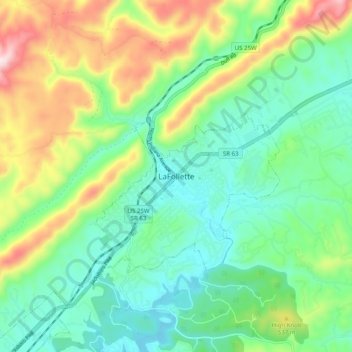
Name: LaFollette topographic map, elevation, terrain.
Average elevation: 435 m
Minimum elevation: 301 m
Maximum elevation: 726 m
According to the United States Census Bureau, the city has a total area of 4.9 sq mi (12.7 km2), all land. The elevation varies around the city, around 1,050 ft (320 m) in the valley areas to 1,500 ft (460 m) on ridge tops. The average elevation is around 1,150 ft (350 m).