
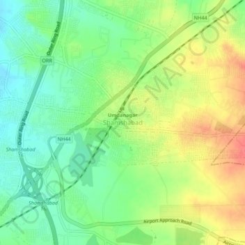
Shamshabad topographic map
Interactive map
Click on the map to display elevation.
About this map
Name: Shamshabad topographic map, elevation, terrain.
Average elevation: 574 m
Minimum elevation: 549 m
Maximum elevation: 606 m
Other topographic maps
Click on a map to view its topography, its elevation and its terrain.
ChengiCherla Cheruvu aka Pochamma Kunta
India > Telangana > Medipally mandal > Chengicherla
Average elevation: 510 m
Ward 106 Serilingampally
India > Telangana > Serilingampalle mandal > Hyderabad
Average elevation: 588 m
Nagarkurnool
Nagarkurnool is located at 18°00′N 79°35′E / 18.0°N 79.58°E / 18.0; 79.58. It has an average elevation of 458 metres (1503 feet).It is settled in the central Deccan Plateau and northern part of Nallamalla Hills made up of granite rocks and hill formations. Most of the region is occupied by…
Average elevation: 419 m
Greater Hyderabad Municipal Corporation North Zone
India > Telangana > Quthbullapur mandal > Hyderabad
Average elevation: 566 m
Greater Hyderabad Municipal Corporation Central Zone
Average elevation: 533 m
Greater Hyderabad Municipal Corporation South Zone
Average elevation: 535 m
Safilguda Lake Park
India > Telangana > Malkajgiri mandal > Hyderabad > Malkajgiri
Average elevation: 543 m
Upper Manair Dam
India > Telangana > Gambhiraopet mandal > Desaipet > Maneru Camp
Average elevation: 449 m