
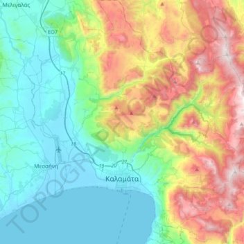
Municipality of Kalamata topographic map
Interactive map
Click on the map to display elevation.
About this map
Name: Municipality of Kalamata topographic map, elevation, terrain.
Average elevation: 490 m
Minimum elevation: -3 m
Maximum elevation: 1,606 m
Other topographic maps
Click on a map to view its topography, its elevation and its terrain.
Voreio
Greece > Peloponnese, Western Greece and the Ionian > Messenia Regional Unit > Municipal Unit of Avia
Voreio, Municipal Unit of Avia, Municipality of West Mani, Messenia Regional Unit, Peloponnese Region, Peloponnese, Western Greece and the Ionian, 240 16, Greece
Average elevation: 668 m
Palace of Nestor
Greece > Peloponnese, Western Greece and the Ionian > Messenia Regional Unit > Chora > Pisaski
Palace of Nestor, Old National Highway 9, Pisaski, Chora, Municipality of Pylos and Nestor, Messenia Regional Unit, Peloponnese Region, Peloponnese, Western Greece and the Ionian, 246 00, Greece
Average elevation: 146 m
Diavolitsi
Greece > Peloponnese, Western Greece and the Ionian > Messenia Regional Unit
Diavolitsi, Municipality of Oichalia, Messenia Regional Unit, Peloponnese Region, Peloponnese, Western Greece and the Ionian, 240 08, Greece
Average elevation: 157 m
Municipality of Pylos and Nestor
Greece > Peloponnese, Western Greece and the Ionian > Messenia Regional Unit
Municipality of Pylos and Nestor, Messenia Regional Unit, Peloponnese Region, Peloponnese, Western Greece and the Ionian, Greece
Average elevation: 101 m
Καλαμάκι
Greece > Peloponnese, Western Greece and the Ionian > Messenia Regional Unit
Καλαμάκι, Municipality of Pylos and Nestor, Messenia Regional Unit, Peloponnese Region, Peloponnese, Western Greece and the Ionian, Greece
Average elevation: 344 m
Exochori
Greece > Peloponnese, Western Greece and the Ionian > Messenia Regional Unit > Municipal Unit of Lefktro
Exochori, Municipal Unit of Lefktro, Municipality of West Mani, Messenia Regional Unit, Peloponnese Region, Peloponnese, Western Greece and the Ionian, 240 22, Greece
Average elevation: 501 m
Pylos
Greece > Peloponnese, Western Greece and the Ionian > Messenia Regional Unit
Pylos, Municipality of Pylos and Nestor, Messenia Regional Unit, Peloponnese Region, Peloponnese, Western Greece and the Ionian, 240 01, Greece
Average elevation: 79 m
Κυπαρισσία
Greece > Peloponnese, Western Greece and the Ionian > Messenia Regional Unit > Kyparissia Municipal Unit > Κυπαρισσία
Κυπαρισσία, Kyparissia Municipal Unit, Municipality of Trifylia, Messenia Regional Unit, Peloponnese Region, Peloponnese, Western Greece and the Ionian, 24500, Greece
Average elevation: 152 m