Geolocate

Nkubu topographic map

Interactive map

Click on the map to display elevation.

About this map

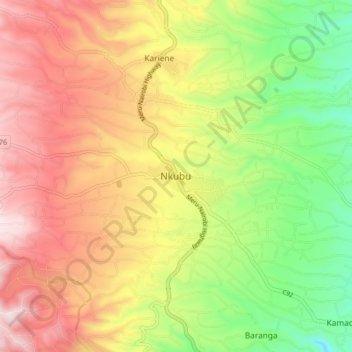
Name: Nkubu topographic map, elevation, terrain.

Location: Nkubu, Imenti South, Meru County, Eastern, Kenya (-0.10630 37.62423 -0.02630 37.70423)

Average elevation: 1,487 m

Minimum elevation: 1,215 m

Maximum elevation: 1,756 m

Other topographic maps

Click on a map to view its topography, its elevation and its terrain.

Igoji

Kenya > Meru County > Imenti South

Igoji, Imenti South, Meru County, Eastern, Kenya

Average elevation: 1,309 m

Baranga

Kenya > Meru County > Imenti South

Baranga, Imenti South, Meru County, Eastern, Kenya

Average elevation: 1,346 m

Mitunguu

Kenya > Meru County > Imenti South

Mitunguu, Imenti South, Meru County, Eastern, Kenya

Average elevation: 1,006 m