Geolocate

Strathan topographic map

Click on the map to display elevation.

About this map

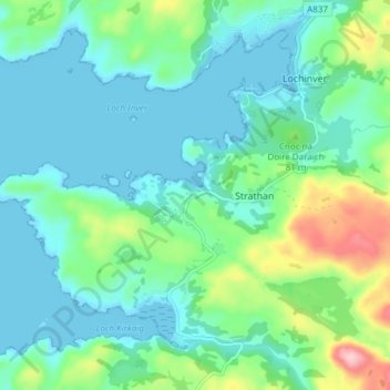
Name: Strathan topographic map, elevation, terrain.

Location: Strathan, Highland, Scotland, IV27 4LR, United Kingdom (58.11677 -5.28048 58.15677 -5.24048)

Average elevation: 42 m

Minimum elevation: 0 m

Maximum elevation: 188 m

Scotland trails, hiking, mountain biking, running and outdoor activities

Gear up for your next adventure:

📦Dry Bags - Waterproof bags to protect gear from rain
🥾Hiking Boot Waterproofing Wax - Maintain the lifespan of your leather trekking boots
🎒Hiking Daypacks - Compact backpacks ideal for short hikes and excursions
👕Technical Hiking Tees - Moisture-management for high-exertion climbs
🗺️Topographic Maps - Detailed maps showing elevation and terrain features

As an Amazon Associate, this site earns from qualifying purchases at no extra cost to you.