
Suez Canal topographic map
Interactive map
Click on the map to display elevation.
About this map
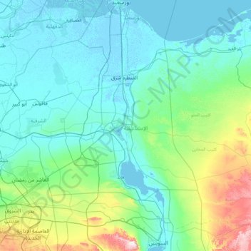
Name: Suez Canal topographic map, elevation, terrain.
Location: Suez Canal, Port Said, 43522, Egypt (29.93034 32.30378 31.27571 32.58750)
Average elevation: 106 m
Minimum elevation: -6 m
Maximum elevation: 869 m
Although the alleged difference in sea levels could be problematic for construction, the idea of finding a shorter route to the east remained alive. In 1830, F. R. Chesney submitted a report to the British government that stated that there was no difference in elevation and that the Suez Canal was feasible, but his report received no further attention. Lieutenant Waghorn established his "Overland Route", which transported post and passengers to India via Egypt.
Other topographic maps
Click on a map to view its topography, its elevation and its terrain.
Al-ʿAbbāsiyyah Canal
Al-ʿAbbāsiyyah Canal, Port Said, 41524, Egypt
Average elevation: 16 m