
Thank you for supporting this site ❤️
Make a donation
Make a donation
Gear up for your next adventure:
As an Amazon Associate, this site earns from qualifying purchases at no extra cost to you.
Lachin topographic map
Click on the map to display elevation.
Thank you for supporting this site ❤️
Make a donation
Make a donation
Gear up for your next adventure:
As an Amazon Associate, this site earns from qualifying purchases at no extra cost to you.
About this map
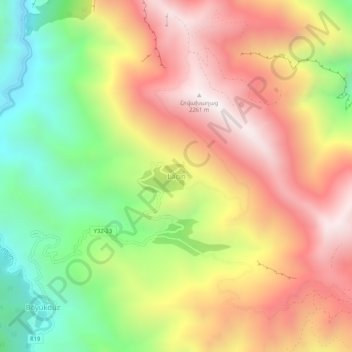
Name: Lachin topographic map, elevation, terrain.
Location: Lachin, Kalbajar District, East Zangezur, Azerbaijan (40.10750 46.23361 40.14750 46.27361)
Average elevation: 1,724 m
Minimum elevation: 1,152 m
Maximum elevation: 2,264 m
Thank you for supporting this site ❤️
Make a donation
Make a donation
Gear up for your next adventure:
As an Amazon Associate, this site earns from qualifying purchases at no extra cost to you.