
Make a donation
Gear up for your next adventure:
As an Amazon Associate, this site earns from qualifying purchases at no extra cost to you.
Δούσκο (Νεμέρτσικα) topographic map
Click on the map to display elevation.
Make a donation
Gear up for your next adventure:
As an Amazon Associate, this site earns from qualifying purchases at no extra cost to you.
About this map
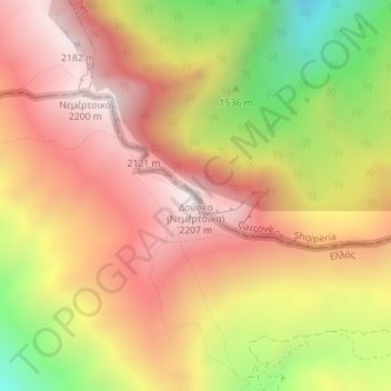
Name: Δούσκο (Νεμέρτσικα) topographic map, elevation, terrain.
Average elevation: 1,750 m
Minimum elevation: 1,110 m
Maximum elevation: 2,192 m
Make a donation
Gear up for your next adventure:
As an Amazon Associate, this site earns from qualifying purchases at no extra cost to you.
Other topographic maps
Click on a map to view its topography, its elevation and its terrain.
Municipality of Grevena
Greece > Epirus and Western Macedonia > Grevena Regional Unit
Average elevation: 878 m
North Tzoumerka Municipality
Greece > Epirus and Western Macedonia > Ioannina Regional Unit
Average elevation: 990 m
Ioannina
Greece > Epirus and Western Macedonia > Ioannina Regional Unit
Ioannina (Greek: Ιωάννινα Ioánnina [i.oˈa.ni.na] ), often called Yannena (Γιάννενα Yánnena [ˈʝa.ne.na]) within Greece, is the capital and largest city of the Ioannina regional unit and of Epirus, an administrative region in north-western Greece. According to the 2011 census, the city…
Average elevation: 493 m
Make a donation
Gear up for your next adventure:
As an Amazon Associate, this site earns from qualifying purchases at no extra cost to you.
Melissovouno
Greece > Epirus and Western Macedonia > Florina Regional Unit > Meliti Municipal Unit > Σιταριά
Average elevation: 634 m
Souli Municipality
Greece > Epirus and Western Macedonia > Thesprotia Regional Unit
Average elevation: 423 m
Louros Dam
Greece > Epirus and Western Macedonia > Preveza Regional Unit > Agios Georgios
Average elevation: 192 m
Make a donation
Gear up for your next adventure:
As an Amazon Associate, this site earns from qualifying purchases at no extra cost to you.