
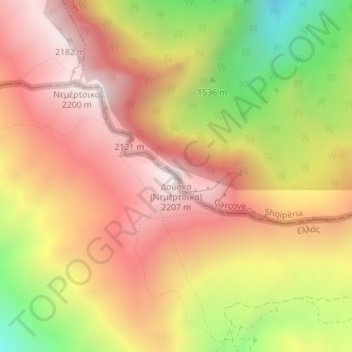
Δούσκο (Νεμέρτσικα) topographic map
Interactive map
Click on the map to display elevation.
About this map
Name: Δούσκο (Νεμέρτσικα) topographic map, elevation, terrain.
Average elevation: 1,750 m
Minimum elevation: 1,110 m
Maximum elevation: 2,192 m
Other topographic maps
Click on a map to view its topography, its elevation and its terrain.
Municipality of Grevena
Greece > Epirus and Western Macedonia > Grevena Regional Unit
Average elevation: 878 m
North Tzoumerka Municipality
Greece > Epirus and Western Macedonia > Ioannina Regional Unit
Average elevation: 990 m
Ioannina
Greece > Epirus and Western Macedonia > Ioannina Regional Unit
Ioannina (Greek: Ιωάννινα Ioánnina [i.oˈa.ni.na] ), often called Yannena (Γιάννενα Yánnena [ˈʝa.ne.na]) within Greece, is the capital and largest city of the Ioannina regional unit and of Epirus, an administrative region in north-western Greece. According to the 2011 census, the city…
Average elevation: 493 m
Melissovouno
Greece > Epirus and Western Macedonia > Florina Regional Unit > Meliti Municipal Unit > Σιταριά
Average elevation: 634 m
Epirus
Greece > Epirus and Western Macedonia
Greek Epirus, like the region as a whole, is rugged and mountainous. It comprises the land of the ancient Molossians and Thesprotians and a small part of the land of the Chaonians, the greater part being in Southern Albania. It is largely made up of mountainous ridges, part of the Dinaric Alps. The region's…
Average elevation: 603 m
Souli Municipality
Greece > Epirus and Western Macedonia > Thesprotia Regional Unit
Average elevation: 423 m
Louros Dam
Greece > Epirus and Western Macedonia > Preveza Regional Unit > Agios Georgios
Average elevation: 192 m