
Mostardas topographic map
Interactive map
Click on the map to display elevation.
Mostardas
Situated on 31º 06' 25" latitude south and 50º 55' 16" longitude west, at an altitude of 17 meters. The city is part of the south shore of the state of Rio Grande do Sul, on an isthmus formed by Laguna dos Patos and Atlantic Ocean. Its population, as estimated by the Census of IBGE of 2020 is 12,847 inhabitants.
About this map
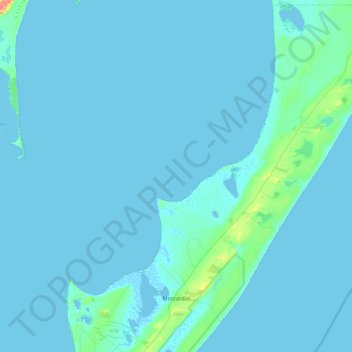
Name: Mostardas topographic map, elevation, terrain.
Average elevation: 3 m
Minimum elevation: -5 m
Maximum elevation: 67 m
Other topographic maps
Click on a map to view its topography, its elevation and its terrain.
Porto Alegre
Brazil > Rio Grande do Sul > Metropolitan Region of Porto Alegre > Porto Alegre
Porto Alegre has a long coastline on the Guaíba Lake, and its topography is punctuated by 40 hills. In the lake, a vast body of water, a maze of islands facing the city creates an archipelago where a unique ecosystem gives shelter to abundant wildlife. The city area concentrates 28% of the native flora of Rio…
Average elevation: 27 m
Pelotas
Brazil > Rio Grande do Sul > Aglomeração Urbana do Sul > Pelotas
As it is situated on a plain near the ocean, the urban area lies on a low elevation, being, on average, 7 meters (23 ft) above sea level. The interior of the municipality is on a plateau called Serras de Sudeste (Southeastern Mountain Ranges). Consequently, the altitude in Pelotas' rural area reaches 429…
Average elevation: 18 m
Parobé
Brazil > Rio Grande do Sul > Metropolitan Region of Porto Alegre > Parobé > Parobé
Average elevation: 62 m