Sohar topographic map
Interactive map
Click on the map to display elevation.
About this map
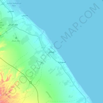
Name: Sohar topographic map, elevation, terrain.
Location: Sohar, Al Batinah North Governorate, 311, Oman (24.18456 56.58248 24.50456 56.90248)
Average elevation: 27 m
Minimum elevation: -2 m
Maximum elevation: 289 m
Other topographic maps
Click on a map to view its topography, its elevation and its terrain.
Wadi al Hilti
Oman > Al Batinah North Governorate > Sohar
Wadi al Hilti, Sohar, Al Batinah North Governorate, Oman
Average elevation: 50 m
Al Khaburah
Oman > Al Batinah North Governorate
Al Khaburah, Al Batinah North Governorate, Oman
Average elevation: 36 m
Majis
Oman > Al Batinah North Governorate
Majis, Al Batinah North Governorate, Oman
Average elevation: 5 m
Sanqar
Oman > Al Batinah North Governorate
Sanqar, Al Batinah North Governorate, Oman
Average elevation: 4 m
Zaab
Oman > Al Batinah North Governorate > Abu Durus
Zaab, Abu Durus, Al Batinah North Governorate, Oman
Average elevation: 2 m
Al Masnaa
Oman > Al Batinah North Governorate > Al Masnaa
Al Masnaa, Al Batinah North Governorate, Oman
Average elevation: 5 m
Saham
Oman > Al Batinah North Governorate > Saham
Saham, Al Batinah North Governorate, 319, Oman
Average elevation: 40 m
As Suwaiq
Oman > Al Batinah North Governorate
As Suwaiq, Al Batinah North Governorate, 207, Oman
Average elevation: 27 m