
Buchanan County topographic map
Interactive map
Click on the map to display elevation.
About this map
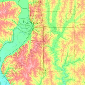
Name: Buchanan County topographic map, elevation, terrain.
Location: Buchanan County, Missouri, United States (39.53031 -95.11344 39.82075 -94.60121)
Average elevation: 288 m
Minimum elevation: 235 m
Maximum elevation: 365 m
Other topographic maps
Click on a map to view its topography, its elevation and its terrain.
Saint Joseph
United States > Missouri > Buchanan County
Saint Joseph, Buchanan County, Missouri, United States
Average elevation: 277 m