
Morón de la Frontera topographic map
Interactive map
Click on the map to display elevation.
Morón de la Frontera
The origins of the city go all the way back to prehistory, with the first human settlement being near the hill where the castle is today. For this reason and the rugged topography of this region, the historical district has steep and narrow roads, but newer sections of the city to the west and northwest have more standard sized roads. Much of the architecture in the city is listed under the categories of Bien de Interés Cultural and conjunto histórico, categories that are part of Spain's national system of heritage listing.
About this map
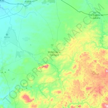
Name: Morón de la Frontera topographic map, elevation, terrain.
Location: Morón de la Frontera, Sevilla, Andalusia, 41530, Spain (37.00456 -5.59132 37.23526 -5.22437)
Average elevation: 216 m
Minimum elevation: 59 m
Maximum elevation: 673 m