
Kluane National Park and Reserve topographic map
Interactive map
Click on the map to display elevation.
About this map
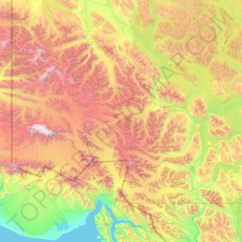
Name: Kluane National Park and Reserve topographic map, elevation, terrain.
Location: Kluane National Park and Reserve, Yukon, Canada (59.99484 -141.00198 61.33741 -137.01009)
Average elevation: 1,536 m
Minimum elevation: -1 m
Maximum elevation: 5,841 m
The Reserve includes the highest mountain in Canada, Mount Logan (5,959 metres or 19,551 feet) of the Saint Elias Mountains. Mountains and glaciers dominate the park's landscape, covering 83% of its area. The rest of the land in the park is forest and tundra—east of the largest mountains and glaciers—where the climate is colder and drier than in the western and southern parts of the park. Trees grow only at the park's lowest elevations. The primary tree species are white spruce, balsam poplar and trembling aspen.
Other topographic maps
Click on a map to view its topography, its elevation and its terrain.
Two Mile Village
Canada > Yukon > Watson Lake
Two Mile Village, Watson Lake, Yukon, Y0A 1C0, Canada
Average elevation: 703 m
Destruction Bay
Canada > Yukon > Destruction Bay
Destruction Bay, Yukon, Y0B 1H0, Canada
Average elevation: 893 m
Dawson City
Canada > Yukon > Dawson City > Dawson City
Dawson City, Yukon, Y0B 1G0, Canada
Average elevation: 510 m
Yukon, Unorganized
City of Whitehorse, Yukon, Unorganized, Yukon, Canada
Average elevation: 1,010 m
Swift River
Canada > Yukon > Swift River
Swift River, Yukon, Unorganized, Yukon, Canada
Average elevation: 1,086 m