
Jinghong City topographic map
Interactive map
Click on the map to display elevation.
About this map
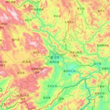
Name: Jinghong City topographic map, elevation, terrain.
Average elevation: 1,120 m
Minimum elevation: 476 m
Maximum elevation: 2,399 m
Other topographic maps
Click on a map to view its topography, its elevation and its terrain.
Gasa
China > Yunnan > Jinghong City > Gasa
Gasa, Jinghong City, Xishuangbanna Dai Autonomous Prefecture, Yunnan, 666100, China
Average elevation: 564 m