
San Antonio topographic map
Interactive map
Click on the map to display elevation.
San Antonio
San Antonio has a rolling topography with elevations varying from a low of 110 feet on the western edge of the city to as high as 183 feet on a hill overlooking Lake Jovita on the eastern edge of town.
About this map
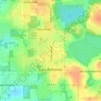
Name: San Antonio topographic map, elevation, terrain.
Location: San Antonio, Pasco County, Florida, United States (28.32827 -82.28922 28.35403 -82.27021)
Average elevation: 44 m
Minimum elevation: 24 m
Maximum elevation: 64 m
Other topographic maps
Click on a map to view its topography, its elevation and its terrain.
Wesley Chapel
United States > Florida > Pasco County
According to the United States Census Bureau, the CDP has a total area of 6.1 square miles (16 km2), of which 6.1 square miles (16 km2) is land and 0.04 square miles (0.10 km2) (0.49%) is water. The elevation is about 100 feet (30 m), combined with an inland location, creates more temperature variation in the…
Average elevation: 19 m