
Ořech topographic map
Interactive map
Click on the map to display elevation.
About this map
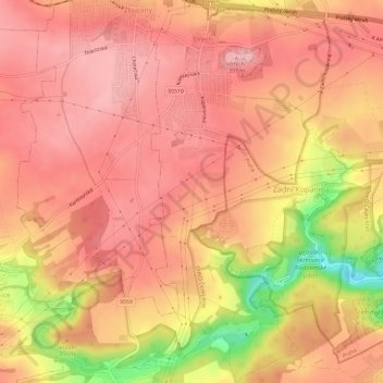
Name: Ořech topographic map, elevation, terrain.
Location: Ořech, Prague, okres Praha-západ, Prague, Czechia (49.98692 14.28839 50.02548 14.31669)
Average elevation: 348 m
Minimum elevation: 247 m
Maximum elevation: 386 m
Other topographic maps
Click on a map to view its topography, its elevation and its terrain.
Letná Park
Letná Park (Czech: Letenské sady) is a large park on Letná hill, built on a plateau above steep embankments along the Vltava River in Prague, Czech Republic. Letná's elevation and location afford commanding views of the Prague Old Town (Staré Město).
Average elevation: 214 m