
Ořech topographic map
Interactive map
Click on the map to display elevation.
About this map
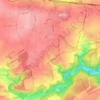
Name: Ořech topographic map, elevation, terrain.
Location: Ořech, Prague, okres Praha-západ, Prague, Czechia (49.98692 14.28839 50.02548 14.31669)
Average elevation: 348 m
Minimum elevation: 247 m
Maximum elevation: 386 m
Other topographic maps
Click on a map to view its topography, its elevation and its terrain.
Letná Park
Letná Park, Holešovice, Praha 1, Prague, Czechia
Average elevation: 214 m
Lesser Town
Lesser Town, Prague, okres Hlavní město Praha, Hlavní město Praha, Prague, Czechia
Average elevation: 233 m