
Alpine topographic map
Interactive map
Click on the map to display elevation.
Alpine
Alpine (/ˈælpaɪn/ AL-pyne) is a city in the county seat of Brewster County, Texas, United States. The population was 5,905 at the 2010 census. The town has an elevation of 4,475 feet (1,364 m), and the surrounding mountain peaks are over 1 mile (1.6 km) above sea level. The university, hospital, library, and retail make Alpine the center of the sprawling 12,000 square miles (3,108,000 ha) but wide open Big Bend area (combined population only 12,500) including Brewster, Presidio, and Jeff Davis counties.
About this map
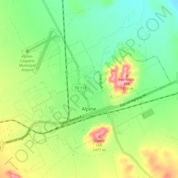
Name: Alpine topographic map, elevation, terrain.
Location: Alpine, Brewster County, Texas, United States (30.34404 -103.70590 30.39172 -103.62556)
Average elevation: 1,373 m
Minimum elevation: 1,305 m
Maximum elevation: 1,493 m
Other topographic maps
Click on a map to view its topography, its elevation and its terrain.
Emory Peak
United States > Texas > Brewster County
The peak can be reached by a moderate hike on a well-marked path across steep rocky terrain with an elevation gain of approximately 2,500 feet (760 m). The Emory Peak Trail is about 1.5 miles (2.4 km) long. The trail is reached by climbing the Pinnacles Trail 3.5 miles (5.6 km) from the Chisos Basin trailhead.…
Average elevation: 2,061 m