
Make a donation
Gear up for your next adventure:
As an Amazon Associate, this site earns from qualifying purchases at no extra cost to you.
Fouday topographic map
Click on the map to display elevation.
Make a donation
Gear up for your next adventure:
As an Amazon Associate, this site earns from qualifying purchases at no extra cost to you.
Fouday
The village is served by the National Road (Route nationale) 420 which connects Strasbourg with Saint-Dié. The town is also traversed by the railway line - here just a single track - that connects these two urban centres. The mountain topography of the region keeps the road and railway running in close parallel along the Bruche Valley.
Make a donation
Gear up for your next adventure:
As an Amazon Associate, this site earns from qualifying purchases at no extra cost to you.
About this map
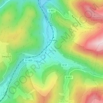
Name: Fouday topographic map, elevation, terrain.
Average elevation: 519 m
Minimum elevation: 373 m
Maximum elevation: 725 m
Make a donation
Gear up for your next adventure:
As an Amazon Associate, this site earns from qualifying purchases at no extra cost to you.