
Jalalabad topographic map
Interactive map
Click on the map to display elevation.
About this map
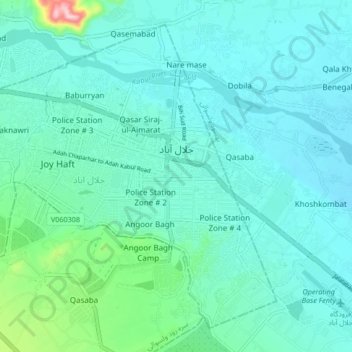
Name: Jalalabad topographic map, elevation, terrain.
Location: Jalalabad, Nangarhar Province, Afghanistan (34.39486 70.40034 34.45443 70.48393)
Average elevation: 579 m
Minimum elevation: 543 m
Maximum elevation: 785 m
The north and southwestern parts of the city which has lower elevation are welcoming places to winds from the north and west cooling the parts in summer months. Jalalabad has the highest relative humidity in summer compared to other Afghan cities. However the moderate temperatures of winter has led to various people down the history establishing their settlements in the city. Because of its warm temperature relative to most of Afghanistan, Jalalabad (alongside Peshawar) was often the "winter capital" of various Afghan rulers of the past centuries, while rich people would relocate to villas in Jalalabad to avoid the freezing temperatures in Kabul.
Other topographic maps
Click on a map to view its topography, its elevation and its terrain.
Mohmand Darah
Afghanistan > Nangarhar Province > Momand Dara
Mohmand Darah, Momand Dara, Nangarhar Province, Afghanistan
Average elevation: 548 m
Sekandara
Afghanistan > Nangarhar Province > Khogyani
Sekandara, Khogyani, Nangarhar Province, Afghanistan
Average elevation: 2,382 m
Lalpur
Afghanistan > Nangarhar Province > Lal Pur > Lalpur
Lalpur, Lal Pur, Nangarhar Province, Afghanistan
Average elevation: 524 m
Taran
Afghanistan > Nangarhar Province > Taran
Taran, Kuz Kunar, Nangarhar Province, Afghanistan
Average elevation: 708 m