
Dransfeld topographic map
Interactive map
Click on the map to display elevation.
About this map
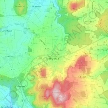
Name: Dransfeld topographic map, elevation, terrain.
Average elevation: 312 m
Minimum elevation: 204 m
Maximum elevation: 489 m
Other topographic maps
Click on a map to view its topography, its elevation and its terrain.
Ossenfeld
Germany > Lower Saxony > Dransfeld > Ossenfeld
Ossenfeld, Dransfeld, Samtgemeinde Dransfeld, Landkreis Göttingen, Lower Saxony, Germany
Average elevation: 317 m