
Make a donation
Gear up for your next adventure:
As an Amazon Associate, this site earns from qualifying purchases at no extra cost to you.
Eryrys topographic map
Click on the map to display elevation.
Make a donation
Gear up for your next adventure:
As an Amazon Associate, this site earns from qualifying purchases at no extra cost to you.
About this map
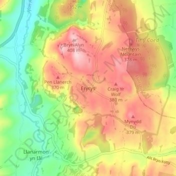
Name: Eryrys topographic map, elevation, terrain.
Location: Eryrys, Denbighshire, Wales, CH7 4BY, United Kingdom (53.09207 -3.21144 53.13207 -3.17144)
Average elevation: 300 m
Minimum elevation: 196 m
Maximum elevation: 404 m
Denbighshire trails, hiking, mountain biking, running and outdoor activities
Make a donation
Gear up for your next adventure:
As an Amazon Associate, this site earns from qualifying purchases at no extra cost to you.
Other topographic maps
Click on a map to view its topography, its elevation and its terrain.
Clwydian Range and Dee Valley National Landscape
United Kingdom > Wales > Denbighshire
Separated by the Vale of Alyn, a second sister range, sometimes regarded (at least partly) as part of the Clwydian Range and included in the AONB since 2011, the Llantysilio and Maesyrchen Mountains, or South Clwyd Mountains extend further south to Acrefair and Gwyddelwern. Alongside the (core–northern)…
Average elevation: 166 m
Make a donation
Gear up for your next adventure:
As an Amazon Associate, this site earns from qualifying purchases at no extra cost to you.
Coed Nant Simon
United Kingdom > Wales > Denbighshire > St Asaph > Llangwyfan
Average elevation: 211 m
Make a donation
Gear up for your next adventure:
As an Amazon Associate, this site earns from qualifying purchases at no extra cost to you.
Make a donation
Gear up for your next adventure:
As an Amazon Associate, this site earns from qualifying purchases at no extra cost to you.
Coed Rhedyn-coch
United Kingdom > Wales > Denbighshire > St Asaph > Marian Cwm
Average elevation: 196 m
Make a donation
Gear up for your next adventure:
As an Amazon Associate, this site earns from qualifying purchases at no extra cost to you.