
Eryrys topographic map
Interactive map
Click on the map to display elevation.
About this map
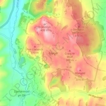
Name: Eryrys topographic map, elevation, terrain.
Location: Eryrys, Denbighshire, Wales, CH7 4BY, United Kingdom (53.09207 -3.21144 53.13207 -3.17144)
Average elevation: 300 m
Minimum elevation: 196 m
Maximum elevation: 404 m
Denbighshire trails, hiking, mountain biking, running and outdoor activities
Other topographic maps
Click on a map to view its topography, its elevation and its terrain.
Coed Rhedyn-coch
United Kingdom > Wales > Denbighshire > St Asaph > Marian Cwm
Average elevation: 196 m