
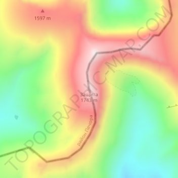
Защита topographic map
Interactive map
Click on the map to display elevation.
About this map
Name: Защита topographic map, elevation, terrain.
Average elevation: 1,340 m
Minimum elevation: 969 m
Maximum elevation: 1,782 m
Other topographic maps
Click on a map to view its topography, its elevation and its terrain.
Пырьях
Russia > Khanty-Mansiysk Autonomous Okrug – Ugra > Khanty-Mansiysky District
Average elevation: 29 m
Chemashi
Russia > Khanty-Mansiysk Autonomous Okrug – Ugra > Oktyabrsky District
Average elevation: 25 m
Сосновка
Russia > Khanty-Mansiysk Autonomous Okrug – Ugra > Beloyarsky District
Average elevation: 100 m
Охтеурье
Russia > Khanty-Mansiysk Autonomous Okrug – Ugra > Nizhnevartovsky District
Average elevation: 51 m
Шайтанка
Russia > Khanty-Mansiysk Autonomous Okrug – Ugra > Beryozovsky District > Beryozovo
Average elevation: 24 m
Верхнеказымский
Russia > Khanty-Mansiysk Autonomous Okrug – Ugra > Beloyarsky District
Average elevation: 40 m
Тайлакова
Russia > Khanty-Mansiysk Autonomous Okrug – Ugra > Surgutsky District
Average elevation: 61 m
Хурумпауль
Russia > Khanty-Mansiysk Autonomous Okrug – Ugra > Beryozovsky District
Average elevation: 21 m
Мозям
Russia > Khanty-Mansiysk Autonomous Okrug – Ugra > Beloyarsky District > Beloyarsky
Average elevation: 41 m
Isluchinsk
Russia > Khanty-Mansiysk Autonomous Okrug – Ugra > Nizhnevartovsky District
Average elevation: 45 m
Сохсъя
Russia > Khanty-Mansiysk Autonomous Okrug – Ugra > Beryozovsky District
Average elevation: 30 m
Megion
Russia > Khanty-Mansiysk Autonomous Okrug – Ugra
Megion (Russian: Мегион) is a town in Khanty-Mansi Autonomous Okrug–Yugra, Russia, located at the altitude of 45 meters (148 ft) above sea level, on the right bank of the Ob River, 380 kilometers (240 mi) east of Khanty-Mansiysk and 760 kilometers (470 mi) northeast of Tyumen. The area of the town is…
Average elevation: 46 m
Цингалы
Russia > Khanty-Mansiysk Autonomous Okrug – Ugra > Khanty-Mansiysky District
Average elevation: 39 m
Лемпино
Russia > Khanty-Mansiysk Autonomous Okrug – Ugra > Nefteyugansky District
Average elevation: 31 m
Салым
Russia > Khanty-Mansiysk Autonomous Okrug – Ugra > Nefteyugansky District
Average elevation: 52 m
Laryak
Russia > Khanty-Mansiysk Autonomous Okrug – Ugra > Nizhnevartovsky District
Average elevation: 52 m
Соснина
Russia > Khanty-Mansiysk Autonomous Okrug – Ugra > городское поселение Излучинск > Соснина
Average elevation: 38 m
Верхне-Мысовая
Russia > Khanty-Mansiysk Autonomous Okrug – Ugra > Верхне-Мысовая
Average elevation: 34 m
Русскинская
Russia > Khanty-Mansiysk Autonomous Okrug – Ugra > Surgutsky District
Average elevation: 63 m
Megion
Russia > Khanty-Mansiysk Autonomous Okrug – Ugra > Megion
Megion (Russian: Мегион) is a town in Khanty-Mansi Autonomous Okrug–Yugra, Russia, located at the altitude of 45 meters (148 ft) above sea level, on the right bank of the Ob River, 380 kilometers (240 mi) east of Khanty-Mansiysk and 760 kilometers (470 mi) northeast of Tyumen. The area of the town is…
Average elevation: 43 m
Тайлакова
Russia > Khanty-Mansiysk Autonomous Okrug – Ugra > Surgutsky District
Average elevation: 61 m