
Make a donation
Gear up for your next adventure:
As an Amazon Associate, this site earns from qualifying purchases at no extra cost to you.
Smithville topographic map
Click on the map to display elevation.
Make a donation
Gear up for your next adventure:
As an Amazon Associate, this site earns from qualifying purchases at no extra cost to you.
About this map
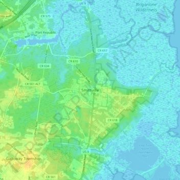
Name: Smithville topographic map, elevation, terrain.
Average elevation: 7 m
Minimum elevation: -2 m
Maximum elevation: 24 m
Make a donation
Gear up for your next adventure:
As an Amazon Associate, this site earns from qualifying purchases at no extra cost to you.
Other topographic maps
Click on a map to view its topography, its elevation and its terrain.
Atlantic City
United States > New Jersey > Atlantic County
Because of its location in South Jersey, which hugs the Atlantic Ocean between marshlands and islands, Atlantic City was viewed by developers as prime real estate and a potential resort town. In 1853, the first commercial hotel, the Belloe House, which was built at the intersection of Massachusetts and…
Average elevation: 1 m
Make a donation
Gear up for your next adventure:
As an Amazon Associate, this site earns from qualifying purchases at no extra cost to you.
Mays Landing
United States > New Jersey > Atlantic County > Hamilton Township > Mays Landing
Average elevation: 7 m
Make a donation
Gear up for your next adventure:
As an Amazon Associate, this site earns from qualifying purchases at no extra cost to you.
Atlantic City
United States > New Jersey > Atlantic County
The city was incorporated in 1854, the same year train service began on the Camden and Atlantic Railroad. Built on the edge of the bay, this served as the direct link of this remote parcel of land with Philadelphia, the second-most populous city in the United States at the time and the largest city in…
Average elevation: 1 m
Make a donation
Gear up for your next adventure:
As an Amazon Associate, this site earns from qualifying purchases at no extra cost to you.
Make a donation
Gear up for your next adventure:
As an Amazon Associate, this site earns from qualifying purchases at no extra cost to you.
Make a donation
Gear up for your next adventure:
As an Amazon Associate, this site earns from qualifying purchases at no extra cost to you.
Atlantic City
United States > New Jersey > Atlantic County
Because of its location in South Jersey, hugging the Atlantic Ocean between marshlands and islands, Atlantic City was viewed by developers as prime real estate and a potential resort town. In 1853, the first commercial hotel, the Belloe House, was built at the intersection of Massachusetts and Atlantic…
Average elevation: 1 m
Make a donation
Gear up for your next adventure:
As an Amazon Associate, this site earns from qualifying purchases at no extra cost to you.
Make a donation
Gear up for your next adventure:
As an Amazon Associate, this site earns from qualifying purchases at no extra cost to you.
Make a donation
Gear up for your next adventure:
As an Amazon Associate, this site earns from qualifying purchases at no extra cost to you.