
Thank you for supporting this site ❤️
Make a donation
Make a donation
Gear up for your next adventure:
As an Amazon Associate, this site earns from qualifying purchases at no extra cost to you.
Chenkottukonam topographic map
Click on the map to display elevation.
Thank you for supporting this site ❤️
Make a donation
Make a donation
Gear up for your next adventure:
As an Amazon Associate, this site earns from qualifying purchases at no extra cost to you.
About this map
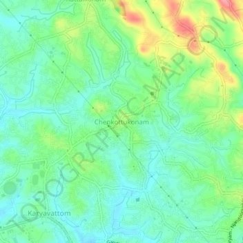
Name: Chenkottukonam topographic map, elevation, terrain.
Location: Chenkottukonam, Thiruvananthapuram, Kerala, 695001, India (8.56243 76.88303 8.60243 76.92303)
Average elevation: 46 m
Minimum elevation: 14 m
Maximum elevation: 116 m
Thank you for supporting this site ❤️
Make a donation
Make a donation
Gear up for your next adventure:
As an Amazon Associate, this site earns from qualifying purchases at no extra cost to you.