
Lee Valley topographic map
Interactive map
Click on the map to display elevation.
About this map
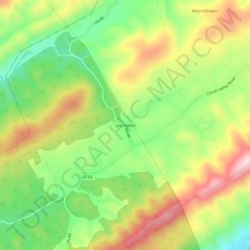
Name: Lee Valley topographic map, elevation, terrain.
Location: Lee Valley, Hawkins County, Tennessee, United States (36.44315 -83.16350 36.48315 -83.12350)
Average elevation: 531 m
Minimum elevation: 380 m
Maximum elevation: 709 m
Other topographic maps
Click on a map to view its topography, its elevation and its terrain.
Greenland
United States > Tennessee > Hawkins County > Church Hill
Greenland, Church Hill, Hawkins County, East Tennessee, Tennessee, United States
Average elevation: 379 m
Eidson
United States > Tennessee > Hawkins County
Eidson, Hawkins County, East Tennessee, Tennessee, 37731, United States
Average elevation: 526 m
Surgoinsville
United States > Tennessee > Hawkins County
Surgoinsville, Hawkins County, East Tennessee, Tennessee, United States
Average elevation: 407 m
Church Hill
United States > Tennessee > Hawkins County > Church Hill
Church Hill, Hawkins County, Tennessee, 37642, United States
Average elevation: 463 m