
Make a donation
Gear up for your next adventure:
As an Amazon Associate, this site earns from qualifying purchases at no extra cost to you.
Stamfani topographic map
Click on the map to display elevation.
Make a donation
Gear up for your next adventure:
As an Amazon Associate, this site earns from qualifying purchases at no extra cost to you.
About this map
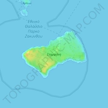
Name: Stamfani topographic map, elevation, terrain.
Average elevation: 1 m
Minimum elevation: -1 m
Maximum elevation: 23 m
Make a donation
Gear up for your next adventure:
As an Amazon Associate, this site earns from qualifying purchases at no extra cost to you.
Other topographic maps
Click on a map to view its topography, its elevation and its terrain.
Porto Roma
Greece > Peloponnese, Western Greece and the Ionian > Zakynthos Regional Unit
Average elevation: 12 m
Lithakia
Greece > Peloponnese, Western Greece and the Ionian > Zakynthos Regional Unit
Average elevation: 153 m
Vardiola in Tsilivi
Greece > Peloponnese, Western Greece and the Ionian > Zakynthos Regional Unit > Planos
Average elevation: 12 m
Kalamaki
Greece > Peloponnese, Western Greece and the Ionian > Zakynthos Regional Unit
Average elevation: 58 m
Make a donation
Gear up for your next adventure:
As an Amazon Associate, this site earns from qualifying purchases at no extra cost to you.