
Lamia topographic map
Interactive map
Click on the map to display elevation.
About this map
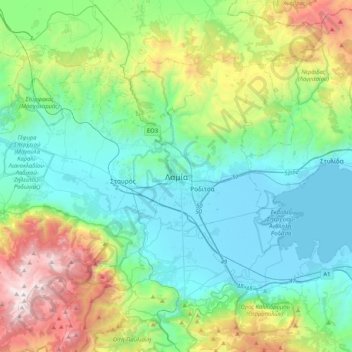
Name: Lamia topographic map, elevation, terrain.
Average elevation: 534 m
Minimum elevation: -4 m
Maximum elevation: 2,141 m
Other topographic maps
Click on a map to view its topography, its elevation and its terrain.
Ypati
Greece > Thessaly and Central Greece > Phthiotis Regional Unit > Δημοτική Ενότητα Υπάτης
Ypati, Δημοτική Ενότητα Υπάτης, Lamia Municipality, Phthiotis Regional Unit, Central Greece, Thessaly and Central Greece, 350 16, Greece
Average elevation: 488 m
Varka
Greece > Thessaly and Central Greece > Phthiotis Regional Unit > Δημοτική Ενότητα Υπάτης > Loutra Ypatis
Varka, Κ. Λουτρών Υπάτης, Loutra Ypatis, Δημοτική Ενότητα Υπάτης, Lamia Municipality, Phthiotis Regional Unit, Central Greece, Thessaly and Central Greece, 350 16, Greece
Average elevation: 166 m
Φούρνοι
Greece > Thessaly and Central Greece > Phthiotis Regional Unit > Αχλάδι
Φούρνοι, Κ. Ραχών, Αχλάδι, Stylida Municipality, Phthiotis Regional Unit, Central Greece, Thessaly and Central Greece, 353 00, Greece
Average elevation: 22 m
Σκάρφεια
Greece > Thessaly and Central Greece > Phthiotis Regional Unit > Σκάρφεια
Σκάρφεια, Kamena Vourla Municipality, Phthiotis Regional Unit, Central Greece, Thessaly and Central Greece, 350 09, Greece
Average elevation: 20 m
Phthiotis Regional Unit
Greece > Thessaly and Central Greece > Phthiotis Regional Unit
Phthiotis Regional Unit, Central Greece, Thessaly and Central Greece, Greece
Average elevation: 480 m