
Lake Nakuru topographic map
Interactive map
Click on the map to display elevation.
About this map
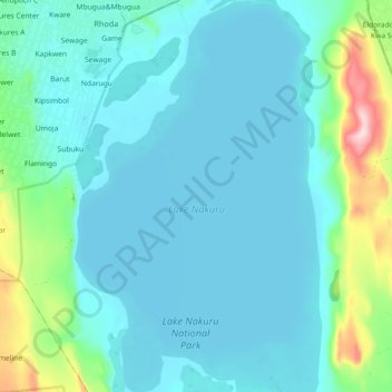
Name: Lake Nakuru topographic map, elevation, terrain.
Location: Lake Nakuru, Kaloleni, Nakuru, Kenya (-0.40762 36.05632 -0.30774 36.11811)
Average elevation: 1,807 m
Minimum elevation: 1,754 m
Maximum elevation: 2,095 m
Lake Nakuru is one of the Rift Valley soda lakes at an elevation of 1,754 m (5,755 ft) above sea level. It lies to the south of Nakuru, in the rift valley of Kenya and is protected by Lake Nakuru National Park.